1

Contract Gis Jobs (NOW HIRING)

GIS Technician

Plummer, ID · On-site

$25 - $30/hr

Produces conventional and digital maps and develops web applications for GIS and other departments and contracts as needed. * Understands and performs GIS databases creation and maintenance. * Helps ...

Location - Atlanta, GA 30308 Client - Georgia Power Contract - 1 Year Position Overview We are seeking a motivated GIS Technician (0-2 Years Experience) to support the Land Department of Georgia ...

GIS Manager

Orlando, FL · On-site

$78.40K - $105.50K/yr

Select and manage outside contract services when needed; Qualifications Requirements: Bachelor ... GIS, OMS, Enterprise One, DocuSphere, FootPrints) o Electric and/or Water utility o Project ...

We offer an excellent compensation package We are looking for GIS Analyst in Columbia, SC for 12+ months Contract position, Please send your resume along with rate expectation sean.c ...

Atlanta, GA (Onsite) Contract :: 24-Months Skills and Responsibilities · 2-4 Years' Experience in a related field. Diploma or certificate in Geographical Information Systems or related curriculum.

Overdrive, Purple's proprietary software-as-a-service ("SaaS"), allows customers to track lease, well, and contract data in a web-based geographic information system ("GIS") mapping platform powered ...

A GIS Technician has a supportive role in the design, development and maintenance of maps and ... Furthermore, they do not establish a contract for employment and are subject to change at the ...

Title - GIS Developer Position - 6 + Months Contract Location -Remote Work / NY Rate - $Open (Best Possible) Requirements Required Experience: * Bachelor's degree in Computer science or related field.

GIS Developer

Phoenix, AZ · On-site

$44/hr

Phoenix, AZ (Two Days Onsite) 6 Months W2 Contract Position Description The GIS Developer is a key member of the GIS team within the Information Technology Division (ITD-GIS), working under the ...

Part-time hours authorized will be less than 1,000 hours for a full contract/calendar year. Travel is required. GIS Analyst Activities: * Provide processing and technical input for the Digital ...

Washington, DC Contract Duration- 6M with very high potential to extend Contract Start Date: Wants to start someone on December 1 or sooner OVERALL PURPOSE OF POSITION: Serves as technical team ...

Contract Pay: $18-$20 per hour Position Overview M Force Partners is seeking a detail-oriented GIS Support Specialist to provide administrative and technical support to the Engineering Communications ...

Atlanta, GA (onsite) Contract: 24-Months The GIS Analyst will develop an understanding of current data state, workflows and processes and develop solutions for integrations, transformations and ...

next page

Showing results 1-20

Contract Gis information

See salary details

$14

$28

$48

How much do contract gis jobs pay per hour?

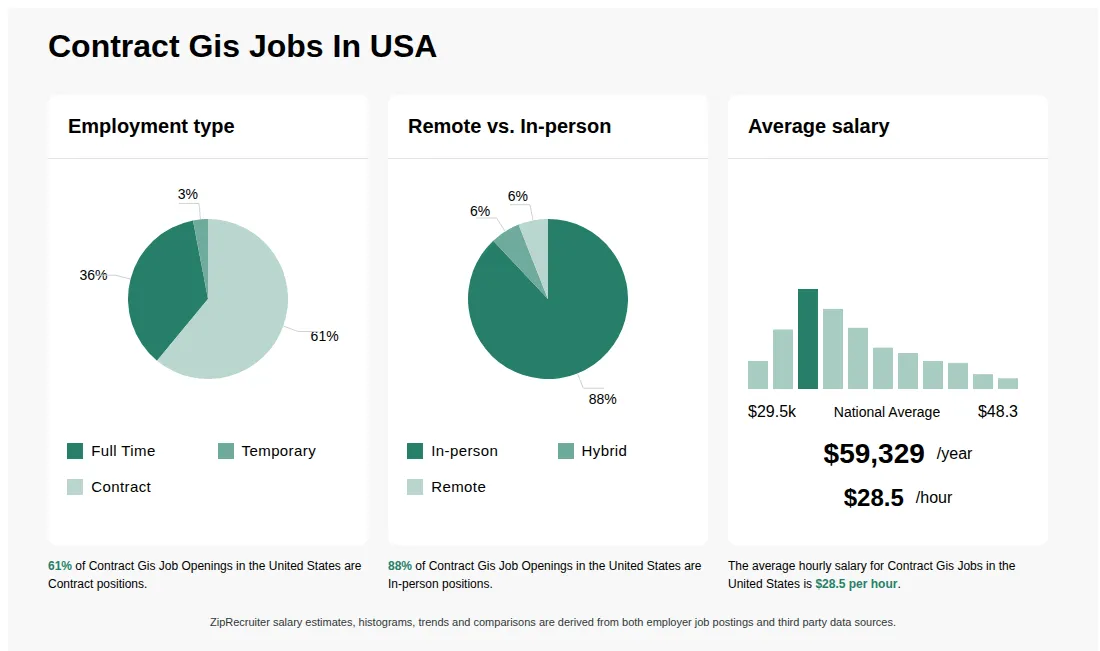
As of May 29, 2026, the average hourly pay for contract gis in the United States is $28.52, according to ZipRecruiter salary data. Most workers in this role earn between $21.63 and $33.65 per hour, depending on experience, location, and employer.

What is a Contract GIS job?

A Contract GIS job involves working on a temporary or project-based basis to perform Geographic Information Systems (GIS) tasks, such as mapping, spatial analysis, and data management. Contractors may work for government agencies, environmental firms, utilities, or private companies that need GIS expertise for specific projects. These roles often require proficiency in GIS software like ArcGIS or QGIS and may involve field data collection, remote sensing, or database management. Contract GIS professionals may work independently or as part of a team, and their contracts can range from a few months to multiple years, depending on project needs.

What are the key skills and qualifications needed to thrive in the Contract Gis position, and why are they important?

To thrive as a Contract GIS professional, you need a solid background in geographic information systems, spatial analysis, cartography, and data management, typically backed by a degree in geography, GIS, or a related field. Expertise with industry-standard software such as Esri ArcGIS, QGIS, and familiarity with GPS and remote sensing tools, as well as certifications like GISP, are highly valued. Strong problem-solving abilities, attention to detail, and clear communication skills are important soft skills in this role. These qualifications enable Contract GIS professionals to deliver accurate, actionable spatial data to support organizational planning and decision-making.

What are some typical projects or tasks that Contract GIS professionals handle on a daily basis?

As a Contract GIS professional, your daily tasks may include collecting, processing, and analyzing spatial data, creating digital maps, updating geospatial databases, and generating reports for various stakeholders. You may also collaborate closely with engineers, planners, environmental scientists, and IT teams depending on the industry you support. Projects often range from environmental impact assessments and land use planning to utility mapping and transportation analysis. Working on a contract basis, you may be involved in short-term or project-based assignments, which provides exposure to a variety of industries and challenges. This dynamic work environment is ideal for those who enjoy applying their GIS expertise to solve real-world problems.
What cities are hiring for Contract Gis jobs? Cities with the most Contract Gis job openings:
What are the most commonly searched types of Gis jobs? The most popular types of Gis jobs are:
What states have the most Contract Gis jobs? States with the most job openings for Contract Gis jobs include:
What job categories do people searching Contract Gis jobs look for? The top searched job categories for Contract Gis jobs are:
GIS Coordinator (GIS Project Manager)

GIS Coordinator (GIS Project Manager)

Metropolitan Council

Saint Paul, MN • Hybrid

$95.80K - $155.40K/yr

Full-time

This job post has expired today. Applications are no longer accepted.


Metropolitan Council rating

7.4

Company rating: 7.4 out of 10

Based on 5 frontline employees who took The Breakroom Quiz

414th of 638 rated public administrative organizations


Job description

WHO WE ARE This position is eligible for a hybrid telework arrangement (both remote and onsite). Candidate's permanent residence must be in Minnesota or Wisconsin. We are the Metropolitan Council, the regional government for the seven-county Twin Cities metropolitan area.

We plan 30 years ahead for the metropolitan area and provide regional transportation, wastewater, and housing services. More information about us is on our website. We are committed to supporting a diverse workforce that reflects the communities we serve.

Information Services is the central IT department supporting all divisions of the Metropolitan Council. Our 140 team members provide technology, practices, and innovative solutions that enable the Council's core services. How your work would contribute to our organization and the Twin Cities region: The GIS Coordinator (GIS Project Manager) is part of the Council's core GIS team in the IS Department and works with all Metropolitan Council Divisions (Metro Transit, Environmental Services, Community Development, Metropolitan Transportation Services, and Regional Administration), overseeing the planning, execution, and delivery of Geographic Information Systems (GIS) projects.

This role ensures that technical teams, project stakeholders, and organizational leadership stay aligned on project goals, timelines, data quality, and outcomes. The GIS Project Manager combines project management expertise with strong geospatial knowledge to lead complex initiatives supporting analysis, mapping, planning, and decision-making. What you would do in this job Lead end-to-end management of GIS projects, including scope definition, gathering technical requirements, planning, scheduling, budgeting, and risk mitigation.

This includes responsibilities to: Understand business requirements and translate them into technical requirements Create project plans Clarify the tasks needed to complete plans Work with Executive Sponsors, Product Owners, and SMEs across the business and in IS functional areas to deliver the project on time Collaborate with internal stakeholders, subject matter experts, and external partners to gather requirements and define project objectives. Oversee the development, integration, and maintenance of GIS data, applications, and workflows. Ensure the quality, accuracy, completeness, and metadata compliance of spatial datasets and mapping products.

Coordinate with GIS analysis developers and data specialists to manage workflows and resolve technical issues. Monitor project progress and provide regular status updates, reports, and dashboards to leadership and stakeholders. Implement and uphold GIS standards, best practices, and data governance policies.

Support the evaluation and adoption of new GIS technologies, tools, and methods. Facilitate training, workshops, and user support for GIS applications and project deliverables. Manage vendor relationships, procurements, and contracts where required.

Participate in regional or intergovernmental GIS committees or working groups. Drive adoption through consistent communications with customers. Identity needed IS partners, such as DBAs, Developers, and System Engineers, and ensure they have the resources necessary to support the service.

What education and experience are required for this job (minimum qualifications) Education/Experience: Any of the following combinations of experience (applying GIS to support government/private operations and managing projects) and completed education (degree field of study in Computer Science, Geography, GIS or related field): High school diploma/GED with nine (9) years of experience Associate degree with seven years (7) of experience Bachelor's degree with five years (5) of experience Master's degree with three years (3) of experience Desired Qualification Experience with geospatial data and applications, including ArcGIS Products Experience with managing multiple complex projects simultaneously. Experience with the application of GIS concepts and standards. Ability to write clear, concise, and logical reports.

Ability to make clear verbal and written presentations. Ability to plan and facilitate conversations. Ability to effectively communicate to a wide variety of audiences and stakeholders.

Ability to plan, arrange, and conduct meetings. Ability to effectively juggle multiple projects simultaneously. Experience working and collaborating in diverse, multicultural, and inclusive environments.

Knowledge, Skills, and Abilities Knowledge of a broad range of geographic principles and the application of GIS concepts and standards. Familiarity with Esri ArcGIS platforms (ArcGIS Pro, ArcGIS Online, ArcGIS Enterprise). Knowledge of spatial data structures, geodatabases, and metadata standards.

Understanding of project management methodologies (Agile, Waterfall, hybrid approaches). Knowledge of relevant data governance, data quality, and data security standards. Awareness of enterprise IT (ITSM) concepts, system integrations, cloud environments, and APIs.

Ability to plan, facilitate, and conduct effective meetings Strong project planning, scheduling, and coordination skills. Ability to manage budgets, timelines, scope, and resources. Skilled in defining project requirements and translating needs into technical tasks.

Proficiency in generating high-quality maps, dashboards, and analytical products. Strong documentation, reporting, and status-tracking skills. Effective communication with both technical and non-technical audiences Strong problem-solving and analytical thinking skills.

Ability to lead cross-functional teams and build consensus among diverse stakeholders. Ability to manage multiple complex projects simultaneously. Ability to assess risks and develop proactive mitigation strategies.

Ability to explain geospatial concepts in clear, accessible terms. Ability to adapt to changing priorities, technologies, and organizational needs. Ability to promote standards, best practices, and quality assurance within GIS operations.

Additional information Union/Grade: AFSCME/Grade I FLSA Status: Exempt Safety Sensitive: No Work Environment: Work is performed in a standard office setting. May require travel between the primary work site and other sites.