2

Remote Sensing Scientist Jobs (NOW HIRING)

Remote Commitment: 40 hours/week Role Responsibilities * Guide research teams to close knowledge ... Develop evaluation frameworks and rubrics for assessing scientific reasoning quality across STEM ...

Apply Early

Remote Commitment: 40 hours/week Role Responsibilities * Guide research teams to close knowledge ... Develop evaluation frameworks and rubrics for assessing scientific reasoning quality across STEM ...

Apply Early

next page

Showing results 1-20

Remote Sensing Scientist information

See salary details

$83.5K

$127K

$171K

How much do remote sensing scientist jobs pay per year?

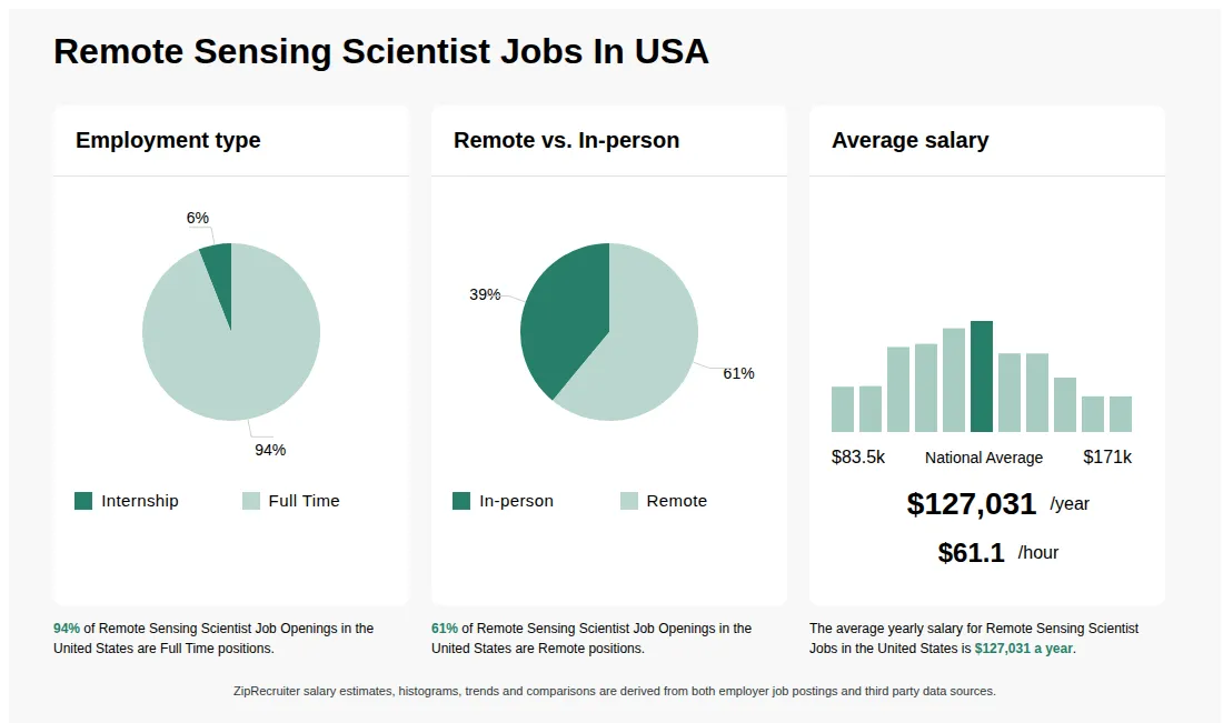
As of Jul 5, 2026, the average yearly pay for remote sensing scientist in the United States is $127,031.00, according to ZipRecruiter salary data. Most workers in this role earn between $109,000.00 and $143,500.00 per year, depending on experience, location, and employer.

What is the difference between Remote Sensing Scientist vs GIS Analyst?

AspectRemote Sensing ScientistGIS Analyst
Required CredentialsBachelor's/Master's in Remote Sensing, Geospatial Science, or related fieldsBachelor's/Master's in Geography, GIS, or related fields
Work EnvironmentResearch labs, government agencies, environmental firmsUrban planning, environmental consulting, government agencies
Industry UsageSatellite data analysis, environmental monitoringMapping, spatial data analysis, infrastructure planning
Common Search IntentRemote sensing data interpretation, satellite imagery analysisGIS mapping, spatial data management

While both roles involve geospatial data, Remote Sensing Scientists focus on analyzing satellite and aerial imagery to monitor environmental changes, whereas GIS Analysts primarily work with geographic information systems to create maps and analyze spatial data for planning and decision-making.

What Does a Remote Sensing Scientist Do?

Remote sensing scientists analyze data using sensors to solve problems related to local issues like urban planning to global complications like natural resource management. As a remote sensing scientist, your responsibilities include using statistical analysis or image analysis software to analyze data acquired by aircraft, satellites, and other platforms. You monitor atmospheric changes, better understand geospatial information, and even help influence decision making regarding fair and equitable land use. Remote sensing scientists are closely involved in innumerable fields.

What are the key skills and qualifications needed to thrive as a Remote Sensing Scientist, and why are they important?

To thrive as a Remote Sensing Scientist, you need a strong background in geospatial analysis, image processing, and a relevant degree in fields such as geography, environmental science, or engineering. Familiarity with GIS software (like ArcGIS or QGIS), remote sensing tools (such as ENVI or ERDAS Imagine), and programming languages (Python, R) is typically required. Analytical thinking, attention to detail, and effective communication are crucial soft skills for interpreting data and presenting findings. These competencies are vital for accurately analyzing earth observation data, supporting decision-making, and ensuring the reliability of scientific conclusions.

What are Remote Sensing Scientists?

Remote Sensing Scientists are professionals who use satellite or airborne sensor data to analyze and interpret information about the Earth's surface and atmosphere. They apply techniques from physics, geography, and computer science to process and analyze remotely sensed images for applications such as environmental monitoring, agriculture, urban planning, and disaster management. Their work often involves using software to manipulate geospatial data and create maps or models that inform decision-making. Remote Sensing Scientists may work in government agencies, research institutions, or private industry, and often collaborate with other scientists and engineers.

What are some typical challenges Remote Sensing Scientists face when working with large datasets?

Remote Sensing Scientists often work with massive amounts of satellite or aerial imagery, which can present challenges related to data storage, processing speed, and data quality management. Ensuring the accuracy of image analysis and integrating data from multiple sensor types or platforms can also be complex. To address these issues, scientists frequently rely on high-performance computing, cloud-based platforms, and advanced algorithms for data preprocessing and analysis. Collaborating closely with data engineers and software developers is common to streamline workflow and maintain data integrity.
What cities are hiring for Remote Sensing Scientist jobs? Cities with the most Remote Sensing Scientist job openings:
What states have the most Remote Sensing Scientist jobs? States with the most job openings for Remote Sensing Scientist jobs include:
Infographic showing various Remote Sensing Scientist job openings in the United States as of June 2026, with employment types broken down into 31% Full Time, 46% Part Time, and 23% Contract. Highlights an 37% Physical, 3% Hybrid, and 60% Remote job distribution, with an average salary of $127,031 per year, or $61.1 per hour.
Mission Architect (Remote Sensing)

Mission Architect (Remote Sensing)

Moseley Technical Services, Inc.

El Segundo, CA • On-site, Remote

$164K - $276K/yr

Full-time

Posted yesterday


Job description

Check out this new opportunity!
Mission Architect (Remote Sensing)
On-site in El Segundo, CA
Target salary range: $164,050 - $276,250
Mission Architect job in El Segundo, California is available with Moseley Technical Services Top Space / Defense company! In this full time, direct hire, salaried job you will join a fast, agile satellite company focused on national security as an OPIR/Tracking Systems Subject Matter Expert, overseeing mission architecture and spacecraft/constellation design across many programs. Manage all aspects of design, development, and fielding Remote Sensing (RS) space segments, including integration with ground and user segments; modeling and simulation to validate mission scenarios and system performance against Key Performance Parameters (KPPs); assessing sensor design, development, and performance; decomposing requirements for payload / algorithm vendors; and writing proposals, requirements definition, system design, integration, test and on-orbit operations.
Responsibilities:
  • Define architecture and system requirements for OPIR missions
  • Lead modeling and simulation efforts to assess system performance
  • Develop CONOPS at the spacecraft, constellation, and mission level
  • Architect and implement Mission Data Processing (MDP) algorithms (onboard and ground-based)
  • Oversee mission level budgets and KPPs (e.g. LOS knowledge, jitter/smear, optical transmission, latency, etc.)
  • Ensure space system (including Electro-Optical/Infrared (EO/IR) payloads and bus components) meet mission level requirements

Qualifications:
  • U.S. Citizenship is required by Federal Law
    Active Secret Clearance required
  • Bachelor's degree in engineering or physical / computer science
  • 12+ years of experience in the design, development, delivery, and operation of space-based remote sensing missions
  • Subject Matter Expertise in earth-observing EO/IR missions
  • Expertise in development of mission modeling and simulation tools to assess sensing mission performance
  • Expertise in the design and performance of EO/IR sensors

Moseley Technical Services, Inc. is an AA/EEO/Veterans/Disabled Employer
What to Expect
Moseley Technical Services, Inc. (Moseley) was incorporated in 1994 to provide engineering and professional services to the aerospace/defense, manufacturing, government, and commercial industries. Our Mission is to deliver superior service to our customers and employees. We have achieved our vision by building long-term relationships with customers and employees through integrity, transparency, and appreciation.
  • To apply, send a resume to: resumes@moseleytechnical.com
  • For more active job openings: Careers at Moseley Technical
  • For more information about us: Moseley Technical - Mission and Values!

"We stand by our 30-year-old commitment of "World Class Service. World Class Company."

Moseley Technical Services logo

About Moseley Technical Services

Sourced by ZipRecruiter

Moseley Technical Services, headquartered in Huntsville, AL, US, is a renowned player in the engineering services industry. They provide a diverse array of services, primarily focused on staffing and recruiting for various technical industries including aerospace, defense, and information technology. Incepted in 1995, this veteran-owned company prides itself on its strong commitment to its customers’ missions and to its employees.

Industry

Recruiting and staffing services

Company size

201 - 500 Employees

Headquarters location

Huntsville, AL, US

Year founded

1994

Social media