1

Spatial Data Analyst Jobs (NOW HIRING)

In the process, the incumbent will audit GIS data for accuracy and create, delete and edit all spatial data other than cadastral data. Examples of Duties 1. GIS Database Management - Evaluate ...

The Senior GIS Analyst will manage and analyze spatial data, develop GIS applications, and deliver insights to support business and project decision-making. Responsibilities : • Manage and analyze ...

The analyst will take on projects to extract, evaluate, and visualize spatial and non-spatial data for business intelligence purposes and program performance measurement by departments. This will ...

... spatial data pipelines, and ensuring the reliability and integrity of GIS data across the ... Proven experience as a GIS Analyst supporting Land and BD A&D operations * BA/BS in Geography ...

The GIS team at OTI builds various spatial data solutions and products, enabling the analysis and use of Citywide spatial assets. The Lead GIS Analyst will be part of an exciting team to help New ...

... spatial data pipelines, and ensuring the reliability and integrity of GIS data across the ... Proven experience as a GIS Analyst supporting Land and BD A&D operations * BA/BS in Geography ...

Standardize attribute mapping between BIM data schemas and GIS spatial data models. * Configure and maintain cloud-based integration environments. * Spatial Analysis & Digital Twins (30%) * Perform ...

next page

Showing results 1-20

Spatial Data Analyst information

See salary details

$34K

$82.6K

$136K

How much do spatial data analyst jobs pay per year?

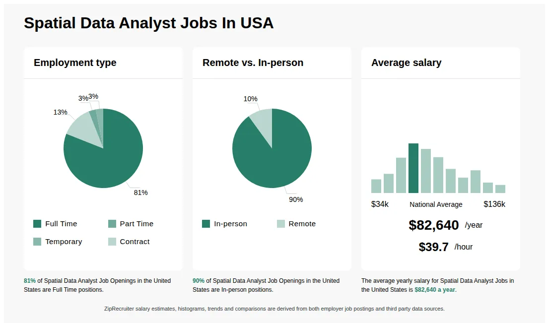
As of May 30, 2026, the average yearly pay for spatial data analyst in the United States is $82,640.00, according to ZipRecruiter salary data. Most workers in this role earn between $62,500.00 and $97,000.00 per year, depending on experience, location, and employer.

What does a Spatial Data Analyst do?

A Spatial Data Analyst collects, analyzes, and interprets geographic and spatial data to support decision-making in various industries. They use Geographic Information Systems (GIS) and other analytical tools to visualize patterns, create maps, and develop models based on spatial data. Their work helps businesses, governments, and organizations optimize operations, plan infrastructure, and manage resources effectively.

What are the key skills and qualifications needed to thrive in the Spatial Data Analyst position, and why are they important?

To thrive as a Spatial Data Analyst, you need strong skills in GIS (Geographic Information Systems), spatial data analysis, database management, and a solid understanding of geography or related fields, often supported by a relevant degree. Familiarity with tools like ArcGIS, QGIS, SQL, Python, and sometimes certifications such as GISP are highly valuable. Attention to detail, problem-solving abilities, and effective communication enhance collaboration with teams and stakeholders. These competencies ensure accurate spatial analysis, meaningful data-driven insights, and effective decision-making in diverse industries.

What are some typical projects or tasks a Spatial Data Analyst might work on?

Spatial Data Analysts often work on a variety of projects involving the collection, management, and analysis of geographic data, such as mapping environmental patterns, optimizing logistics routes, or supporting urban planning initiatives. On a daily basis, they may clean and process datasets, generate detailed maps, create visualizations and reports, and provide insights to inform project decisions. Collaboration with engineers, urban planners, environmental scientists, and IT professionals is common, making teamwork and clear communication essential. These tasks are integral to helping organizations make data-driven decisions that rely on spatial information.
What cities are hiring for Spatial Data Analyst jobs? Cities with the most Spatial Data Analyst job openings:
What are the most commonly searched types of Spatial Data Analyst jobs? The most popular types of Spatial Data Analyst jobs are:
What states have the most Spatial Data Analyst jobs? States with the most job openings for Spatial Data Analyst jobs include:
Infographic showing various Spatial Data Analyst job openings in the United States as of May 2026, with employment types broken down into 94% Full Time, 2% Part Time, and 4% Contract. Highlights an 91% Physical, 7% Hybrid, and 2% Remote job distribution, with an average salary of $82,640 per year, or $39.7 per hour.

$47.43K - $54.55K/yr

Full-time

Posted 11 days ago


Job description

Description This position is responsible analyzing, preparing and prioritizing special GIS projects for departments, public groups and individuals. This may include research and recommending solutions to the problems that arise. In the process, the incumbent will audit GIS data for accuracy and create, delete and edit all spatial data other than cadastral data.

Examples of Duties 1. GIS Database Management - Evaluate existing county spatial data for accuracy and completeness and make additions, changes and deletions as necessary. Suggest modifications to database structure to optimize GIS operations.

Perform weekly data load to production database. In particular, keep county centerline and emergency response data current and accurate. 2.

Spatial Data Analysis and Cartography - Conduct ad hoc and recurring analyses of geospatial data to produce information after evaluating the information needed, the datasets required, the analysis procedure and the optimal output format/s. Create clear, information and aesthetically pleasing map products, including, but not limited to, the annual Road Atlas. Occasionally, the spatial analysis request is for information that is not readily available or are to solve problems that are unique.

Knowing what the system can do, what data is available and how to manipulate the data is critical to this task. 3. Technical/Managerial Support - Assist with software installation, troubleshooting, hardware issues and web administration.

Conduct QA/QC of cadastral mapping output. Train new cadastral mapping staff on cadastral procedures. Maintain official departmental procedure book relating to Technical and Cadastral functions.

Act as supervisor in the absence of GeoServices Manager. 4. Programming - Analyze needs of department and customers and create custom tools to automate specific GIS tasks or solve recurring GIS problems and create simple custom web applications.

Recommend improvements to existing GIS web, database and applications. The major challenges for this position are the handling of conflicting data in the system and time management to complete numerous large assignments. For example, roads may not be where they should be, property boundaries may conflict, or zip codes boundaries may need adjusting.

Data must be reviewed and updated prior to undertaking these projects. The incumbent is free to perform general maintenance to the data and to prioritize projects. The incumbent can work independently within specific guidelines germane to GIS.

Decisions relating to the software, the server, or large undertakings require management approval. Typical Qualifications REQUIRED EDUCATIONAL BACKGROUND AND JOB-RELATED EXPERIENCE: Minimum Level of Job-Related Education: BS in Geography, Engineering or Science field. Minimum Amount of Job-Related Experience: 5 years in GIS using Esri software.

Minimum Level of any Required Qualifications, Licenses, Certificates, Registrations, or any Relevant Knowledge, Job Skill or Equivalent Experience: Esri product knowledge, GIS programming