1

Google Earth Driver Jobs (NOW HIRING)

Convert field notes into Google Earth/KMZ format (preferred). * Identify constructability issues ... Valid driver's license and reliable transportation. Additional Requirements: * Flexible to travel ...

Convert field notes into Google Earth/KMZ format (preferred). * Identify constructability issues ... Valid driver's license and reliable transportation. Additional Requirements: * Flexible to travel ...

next page

Showing results 1-20

Google Earth Driver information

See salary details

$16

$22

$26

How much do google earth driver jobs pay per hour?

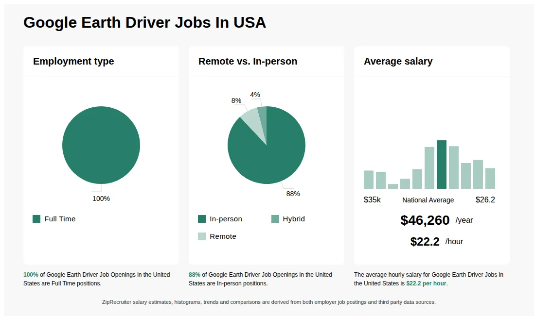
As of Jul 28, 2026, the average hourly pay for google earth driver in the United States is $22.24, according to ZipRecruiter salary data. Most workers in this role earn between $20.91 and $24.04 per hour, depending on experience, location, and employer.

What is the difference between Google Earth Driver vs GIS Technician?

AspectGoogle Earth DriverGIS Technician
Required CredentialsDriver's license, basic geographic knowledgeAssociate's or Bachelor's in GIS, certifications
Work EnvironmentField driving, outdoor data collectionOffice, GIS software, data analysis
Employer & IndustryMapping companies, survey firmsGovernment agencies, environmental firms
Common Search & ComparisonYesNo

Google Earth Driver primarily involves driving to collect geographic data and operate mapping equipment, often outdoors. GIS Technicians focus on analyzing spatial data using specialized software in an office setting. While both roles work with geographic information, their credentials, work environment, and job functions differ significantly.


How to get hired by Google Maps?

To become a Google Earth Driver or similar role related to Google Maps, candidates typically need experience in geographic information systems (GIS), mapping, or related fields, along with strong technical skills and familiarity with mapping tools. Applying through Google's careers website and demonstrating relevant experience, certifications, or skills in spatial data management can improve chances of being hired.

How do I become a Google Earth driver?

A Google Earth driver is not a formal job title; if referring to roles involving geographic data or mapping, relevant skills include GIS, cartography, or remote sensing, along with proficiency in tools like Google Earth and related software. Gaining experience through certifications, technical training, or related positions in geospatial industries can help pursue such roles.

What are Google Earth Drivers?

Google Earth Drivers are individuals responsible for operating vehicles equipped with specialized cameras and sensors that capture imagery for Google Earth and Google Maps. Their main job is to drive along designated routes, collecting street-level photographs and geographic data. This imagery is then processed and added to Google’s mapping platforms, helping users explore and navigate real-world locations virtually. Google Earth Drivers must follow specific guidelines to ensure privacy and accuracy while collecting data. The role often involves travel, attention to detail, and adherence to safety standards.

What are some common challenges faced by Google Earth Drivers while capturing street-level imagery?

Google Earth Drivers often encounter challenges such as navigating unfamiliar or remote areas, dealing with varying weather conditions, and adhering to strict route schedules. They must also ensure the camera equipment is functioning properly and troubleshoot any technical issues on the road. Additionally, drivers need to follow privacy guidelines, avoiding capturing sensitive information, and communicate effectively with local authorities or the public when necessary.

Does the Google Earth car have a driver?

The Google Earth car is operated by a professional driver who navigates the vehicle while capturing imagery for mapping purposes. Drivers typically have specialized training in vehicle operation and safety protocols to ensure accurate data collection. The vehicle is not autonomous and requires human oversight during data collection missions.

How do you get a job with Google Earth?

A Google Earth driver is not an official job title; however, roles related to geographic data, mapping, or GIS often require skills in geospatial software, programming, and data analysis. To pursue such positions, candidates typically need relevant education, experience with tools like Google Earth or GIS software, and a strong understanding of geographic information systems.

What are the key skills and qualifications needed to thrive as a Google Earth Driver, and why are they important?

To thrive as a Google Earth Driver, you need a valid driver's license, a clean driving record, and attention to detail to safely operate specialized mapping vehicles. Familiarity with GPS navigation systems, onboard computing devices, and camera equipment is typically required. Reliability, adaptability, and strong communication skills help drivers manage schedules, navigate diverse environments, and report technical issues effectively. These abilities are crucial for collecting high-quality, comprehensive geographic imagery safely and efficiently.
More about Google Earth Driver jobs
What cities are hiring for Google Earth Driver jobs? Cities with the most Google Earth Driver job openings:
What are the most commonly searched types of Google Earth Driver jobs? The most popular types of Google Earth Driver jobs are:
What states have the most Google Earth Driver jobs? States with the most job openings for Google Earth Driver jobs include:
What job categories do people searching Google Earth Driver jobs look for? The top searched job categories for Google Earth Driver jobs are:
Infographic showing various Google Earth Driver job openings in the United States as of July 2026, with employment types broken down into 92% Full Time, and 8% Contract. Highlights an 100% In-person job distribution, with an average salary of $46,260 per year, or $22.2 per hour.
OSP Field Engineer

OSP Field Engineer

Startech Networks Inc

Huntsville, AL • On-site

Contractor

Posted 4 days ago


Job description

Title- OSP Field Engineer
Location-Huntsville, AL
Type- Long term project

Position Overview:
The OSP Field Engineer performs field surveys and collects data to support fiberoptic and telecommunications engineering projects. This role documents existing aerial and underground utility conditions, validates routes, captures measurements, and ensures all information required for accurate design and permitting is collected.

Key Responsibilities:
  • Perform field walks to document poles, underground (UG) paths, utilities, right-of-way (ROW) boundaries, and site conditions.
  • Capture required photos, including pole tags, pole heights, cable labels, MPOE, handholes, anchors, clearances, and obstructions.
  • Measure spans, attachment heights, mid-span clearances, and accurately record GPS coordinates.
  • Take detailed field notes following OSP Design Principles and maintain accurate route documentation.
  • Convert field notes into Google Earth/KMZ format (preferred).
  • Identify constructability issues, easements, utility conflicts, and permitting requirements.
  • Upload and manage field data using platforms such as Katapult Pro or IQGEO.
  • Communicate field findings with Project Managers, Engineering teams, and other stakeholders.

Qualifications:
  • Experience in OSP fielding, telecommunications construction, or utility surveying preferred.
  • AT&T experience is preferred (IFP, ASE, and GPON exposure is a plus).
  • Knowledge of Google Earth with the ability to create or edit KMZ/KML files is a plus.
  • Understanding of FTTx and AT&T GPON design is an advantage.
  • Must be legally authorized to work in the United States.
  • Ability to work outdoors in various weather conditions and perform physically demanding field tasks.
  • Valid driver's license and reliable transportation.

Additional Requirements:
  • Flexible to travel for short business trips and occasional weekend work (rare).
  • Ability to manage timelines efficiently while handling multiple projects simultaneously.
  • Highly organized with the ability to track deadlines, deliverables, and project expectations.

Skills:
  • Field surveying and measurement accuracy.
  • Photo documentation.
  • Map and GIS reading.
  • Problem-solving skills.
  • Time management and organizational skills.
  • Knowledge of aerial and underground telecommunications infrastructure (preferred).