1

Atmospheric Scientist Jobs (NOW HIRING)

What Impact You'll Have GRVTY is seeking a motivated and experienced imagery scientist to provide analytical and geospatial support focused on EO imagery products. The ideal candidate has experience ...

Showing results 41-60

Atmospheric Scientist information

See salary details

$83K

$110.7K

$137K

How much do atmospheric scientist jobs pay per year?

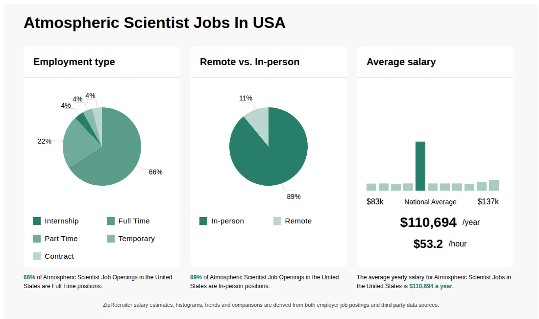
As of Sep 14, 2026, the average yearly pay for atmospheric scientist in the United States is $110,694.00, according to ZipRecruiter salary data. Most workers in this role earn between $104,500.00 and $122,500.00 per year, depending on experience, location, and employer.

What does an atmospheric scientist do?

Atmospheric scientists study the weather to predict short-term and long-term patterns. Some, like meteorologists, may work to forecast the weather over a few of days. Others spend research years of data to create models to learn about weather conditions in the past, or model future climate conditions based on pollution, historical temperatures, precipitation records, and observational tools from space. They report their findings in conferences, professional journals, or research papers. Qualifications for the job include a bachelor’s degree, although many research positions require a master’s degree or doctorate.

What is an atmospheric scientist?

Atmospheric scientists are professionals who study the Earth's atmosphere and how it affects weather, climate, and the environment. They analyze data from satellites, weather stations, and computer models to forecast weather, understand climate change, and research air quality. Atmospheric scientists work in a variety of settings, including government agencies, research institutions, and private industry, often contributing to public safety and environmental policy. Their work helps society prepare for and respond to weather-related events and long-term climate trends.

What are the key skills and qualifications needed to thrive as an atmospheric scientist?

To thrive as an Atmospheric Scientist, you need a solid background in meteorology, mathematics, and physics, typically supported by a relevant degree such as atmospheric science or environmental science. Familiarity with data analysis software, remote sensing tools, and climate modeling systems like Python, MATLAB, and GIS is highly valued. Strong analytical thinking, problem-solving, and effective communication skills distinguish top performers in this field. These abilities are crucial for accurately interpreting complex data and conveying findings to inform public policy, research, and industry decisions.

What are some typical collaborations an atmospheric scientist can expect in their daily work?

Atmospheric Scientists often collaborate with a diverse range of professionals, including meteorologists, climatologists, environmental engineers, and data analysts. These collaborations are essential for interpreting complex climate data, developing predictive weather models, and assessing environmental impacts. Teamwork is especially important during research projects, field studies, or when providing expert input for public policy or environmental planning. Effective communication and interdisciplinary cooperation are key to the role, as many projects rely on integrating findings from multiple scientific fields.

What is the difference between Atmospheric Scientist vs Meteorologist?

AspectAtmospheric ScientistMeteorologist
Required CredentialsBachelor's or higher in atmospheric science, meteorology, or related field; often advanced degreesBachelor's or higher in meteorology or atmospheric science; certifications like AMS are common
Work EnvironmentResearch labs, universities, government agencies, field researchWeather stations, TV stations, government agencies, forecasting centers
Industry UsageResearch, academia, government research projectsWeather forecasting, media, public safety

Atmospheric Scientists focus on research and understanding atmospheric processes, often working in labs or academia. Meteorologists primarily forecast weather and communicate it to the public, working in media or forecasting centers. Both roles require similar educational backgrounds, but their work environments and primary objectives differ.

What cities are hiring for Atmospheric Scientist jobs?

Cities with the most Atmospheric Scientist job openings:

What are the most commonly searched types of Atmospheric Scientist jobs?

The most popular types of Atmospheric Scientist jobs are:

Who are the top companies hiring for Atmospheric Scientist jobs?

The top employers for Atmospheric Scientist jobs are:

What states have the most Atmospheric Scientist jobs?

States with the most job openings for Atmospheric Scientist jobs include:

What are popular job titles related to Atmospheric Scientist jobs?

For Atmospheric Scientist jobs, the most frequently searched job titles are:

Infographic showing various Atmospheric Scientist job openings in the United States as of September 2026, with employment types broken down into 2% Internship, 1% As Needed, 84% Full Time, 10% Part Time, and 3% Contract. Highlights an 81% Physical, 3% Hybrid, and 16% Remote job distribution, with an average salary of $110,694 per year, or $53.2 per hour.

Imagery Scientist (SAR) - Expert with Security Clearance

Falls Church, VA β€’ On-site

$180K - $210K/yr

Contractor

Medical, Retirement, PTO

Re-posted 16 days ago


Job description

What Impact You'll Have GRVTY is seeking a motivated and experienced Imagery Scientist to serve as the subject matter expert on SAR imagery and provide technical direction across the full imagery acquisition and preparation lifecycle. The ideal candidate is an experienced SAR imagery scientist with a passion for advanced scientific problem solving, imagery exploitation, and operational intelligence support. This role will drive solutions informed by specific phenomenology limitations and advantages of sensors and platforms. What You'll be Owning * Integrate emerging sensors and platforms into existing data pipelines and workflows, including: * Develop pipelines and relevant data structures for emerging capabilities * Conduct assessment of potential differences between new sensor characteristics and capabilities compared to currently utilized platforms * Assess potential differences in metadata, data format, and data structure characteristics in regard to changes to: * Databases and schemas * APIs and other ETL-related processes * Ingestion and movement of data within the existing data operations pipeline * Determine how to acquire new data, including: * Potential latency associated with acquisition * Data formats and security domains * Determine how to pre-process and standardize data to match existing standards or be transformed into a usable state for labeling and model development purposes, including: * Converting between file format types * Tiling full-size images into specified sizes or geospatial bounds * Investigate gaps in emerging sensor capabilities that may require supplementation from other sources * Explore options for coincident imagery collects from other imagery platforms to: * Identify EO or other platforms with aligned geographic and temporal coverage * Determine platforms with similar collection window to emerging data types * Develop and implement mathematical conversion models to: * Transform data labels across multiple imagery types (e.g., phase history data to complex image and magnitude detected image) * Develop methods to execute tiling and pre-processing of full-size raw imagery into specified sizes and data formats while maintaining metadata and data integrity * Generate tiles from full-size image collects with specified, precise geospatial boundaries, accounting for orthorectification to ensure geospatial accuracy at tile edges What You Must Have * Active TS/SCI Clearance with the ability to obtain a CI/Poly * Exhibit understanding of: * Collection and phenomenology * Image formation processes * Exploitation products and methodologies * Hands-on experience with SAR data processing tools and libraries including: * SARPy * MATLAB SAR Toolbox * Demonstrated experience with imagery quality metrics, including: * RNIIRS and information theoretic-based image quality metrics * SAR-specific metrics such as Integrated Sidelobe Ratio (ISLR) and Multiplicative Noise Ratio (MNR) * Sensor metadata describing geometry impacts on phenomenology (e.g., graze, squint, azimuth) * Experience exploiting SAR imagery to determine the occurrence and location of objects of interest * Experience developing, testing, and evaluating: * New algorithms, processes, methodologies, and exploitation products * Automated scientific workflows using advanced processing tools including: * Python * MATLAB * Google Earth Engine * Deep understanding of: * Remote Sensing Principles * Advanced imagery processing and exploitation methods * Sensor and platform limitations and advantages * Proven ability to communicate technical concepts to: * Technical audiences * Non-technical stakeholders * Intelligence users What Would be Nice to Have * Experience applying CV and machine learning (ML) techniques to SAR imagery and data to address intelligence problems Pay Range: At GRVTY, we understand that compensation is influenced by many factors-such as geographic location, federal contract labor categories, wage rates, prior experience, skillsets, education, and certifications. We're proud to offer a work environment that empowers our team to achieve a strong work-life balance. GRVTY provides competitive pay, comprehensive benefits, and meaningful opportunities for professional growth. Our benefits package is designed to support the well-being of our employees and their families, and includes coverage in areas such as healthcare, financial wellness, retirement planning, family assistance, continued education, and paid time off. * The pay range for this position is: $180,000 - $210,000