1

Gis Internships Jobs in Florida (NOW HIRING)

GIS & Engineering Intern

Tampa, FL · On-site

$15.25 - $19.75/hr

Interns begin with field GIS data collection, where they interpret plans and as-builts, trace conduit and fiber routes, use utility-locate equipment, and capture accurate spatial and asset data to ...

GIS & Engineering Intern

Tampa, FL · On-site

$15.25 - $19.75/hr

Interns begin with field GIS data collection, where they interpret plans and as-builts, trace conduit and fiber routes, use utility-locate equipment, and capture accurate spatial and asset data to ...

We hire interns in our Community Planning, Landscape Architecture, Engineering, GIS, and Environmental Science departments. We hire interns with the intent to start a long term career with our ...

We hire interns in our Community Planning, Landscape Architecture, Engineering, GIS, and Environmental Science departments. We hire interns with the intent to start a long term career with our ...

Park Services Intern

Tampa, FL · On-site

$16.50/hr

Job Overview The Park Services Internship with Hillsborough County Parks and Recreation offers a ... Proficient in GIS software for data input, export, updates, and generating reports. Computer ...

Environmental Scientist Intern

Orlando, FL · On-site

$15.75 - $20/hr

... interns Primary responsibilities include: • Assist with protected species wildlife surveys • Wetland verification and evaluation • Preparation of environmental technical documents. GIS ...

Environmental Scientist Intern

Orlando, FL · On-site

$15.75 - $20/hr

... interns Primary responsibilities include: Assist with protected species wildlife surveys Wetland verification and evaluation Preparation of environmental technical documents. GIS capabilities ...

next page

Showing results 1-20

Gis Internships information

See Florida salary details

$10

$21

$36

How much do gis internships jobs pay per hour?

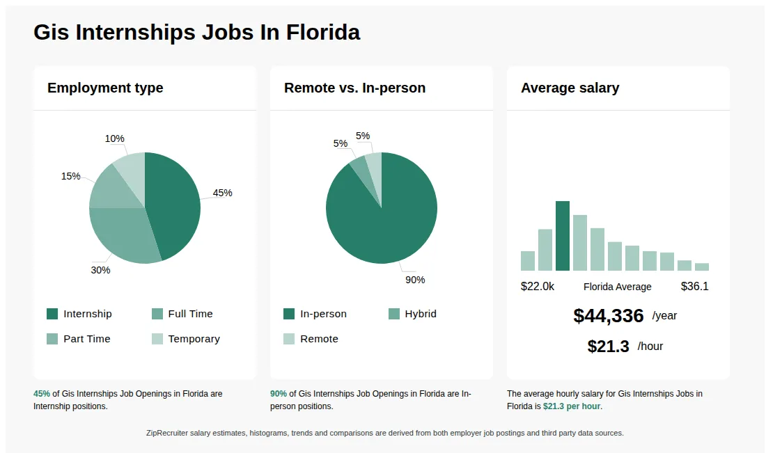
As of Sep 2, 2026, the average hourly pay for gis internships in Florida is $21.32, according to ZipRecruiter salary data. Most workers in this role earn between $16.15 and $25.14 per hour, depending on experience, location, and employer.

What is a GIS internship?

A GIS Internship is an entry-level position where students or recent graduates gain hands-on experience working with Geographic Information Systems (GIS). Interns assist in collecting, analyzing, and visualizing spatial data using mapping software like ArcGIS or QGIS. They may help with data entry, map creation, and spatial analysis for urban planning, environmental studies, or other industries. This role provides valuable real-world exposure to GIS applications and helps build technical and analytical skills.

What types of projects and day-to-day tasks can I expect as a GIS intern?

As a GIS intern, you can expect to support projects involving data collection, spatial analysis, and map production using industry-standard GIS software. Your daily tasks may include digitizing geographic features, maintaining spatial databases, conducting research, and creating visual representations of data for reports or presentations. You might also collaborate with other team members such as GIS analysts, engineers, or environmental scientists on larger projects. This hands-on experience allows you to develop practical skills and build a portfolio that is valuable for future GIS roles.

What are the key skills and qualifications needed to thrive in the GIS internship position, and why are they important?

To thrive in a GIS Internship, you should have a solid understanding of geographic information systems concepts, spatial analysis, and map creation, often supported by coursework or a degree in geography, environmental science, or a related field. Familiarity with GIS software such as ArcGIS or QGIS, and basic data management or programming skills are highly desirable. Strong attention to detail, problem-solving abilities, and effective communication skills help interns contribute meaningfully to projects and collaborative teams. These competencies ensure accurate data analysis and visualization, while fostering growth and success in real-world GIS roles.

How to get a GIS internship?

To secure a GIS internship, candidates should develop skills in GIS software such as ArcGIS or QGIS, build a portfolio of relevant projects, and gain foundational knowledge in geography or related fields. Applying through university career centers, job boards, and company websites, along with networking and obtaining relevant certifications, can improve chances of securing an internship in the field.

Is a GIS internship hard to get?

A GIS internship can be competitive, as many applicants seek these positions to gain experience with GIS software like ArcGIS or QGIS and develop spatial analysis skills. Success often depends on relevant coursework, technical skills, and a strong application demonstrating interest in geospatial technology.

What are the most commonly searched types of Gis Internships jobs in Florida?

The most popular types of Gis Internships jobs in Florida are:

What cities in Florida are hiring for Gis Internships jobs?

Cities in Florida with the most Gis Internships job openings:

Infographic showing various Gis Internships job openings in Florida as of August 2026, with employment types broken down into 4% Internship, 83% Full Time, 11% Part Time, 1% Temporary, and 1% Contract. Highlights an 89% Physical, 3% Hybrid, and 8% Remote job distribution, with an average salary of $44,336 per year, or $21.3 per hour.

Facilities GIS Specialist

Seminole Tribe of Florida

Hollywood, FL • On-site

Full-time

Posted 27 days ago


Job description

Position: Facilities GIS Specialist
Job Type: Full Time
Department: Building and Grounds
Location: HOLLYWOOD
Posted: 08/06/2026
Job Description
The Facilities GIS Specialist supports the Buildings and Grounds Department by collecting, organizing, and maintaining spatial data related to buildings, utilities, landscaped grounds, and other departmental assets. The incumbent is responsible for the acquisition and entry of field data, scanning and digitizing facility features, updating and maintaining spatial datasets, managing GIS web services, and developing GIS-based web applications and dashboards. Under direct supervision, this position assists departmental staff with geospatial workflows, supports planning and maintenance activities, and contributes to safety and operational needs. Bachelor's Degree in Geography, Geophysics, Geomatics, Computer Science, Data Science, Engineering, Mathematics, or related field, with GIS coursework is required. A minimum of two (2) years of GIS-related experience (including academic, internship, or professional work), with at least one (1) year of field experience using GPS is required. Experience working in facilities management and/or asset management software is preferred. Knowledge and understanding of GIS/GPS systems, database principles, cartographic standards, geographic and statistical theory sufficient to perform geographic analyses are required. Geographic Information System Professional (GISP) certification eligibility is preferred. Knowledge and understanding of ESRI products such as ArcGIS Pro 3.X, ArcGIS Online, and Portal for ArcGIS, with ability to learn ESRI mobile field applications is preferred. Possession of a valid Florida Driver's License is required. Demonstrate excellent organizational and interpersonal skills. Demonstrate excellent written and verbal communication skills. Demonstrate proficiency utilizing Microsoft software packages. Ability to work a flexible schedule including evenings, weekends, and holidays.
Benefits:
The Seminole Tribe of Florida provides a comprehensive benefits package.
The Seminole Tribe of Florida is a drug free workplace, drug screening is a requirement of employment. We exercise Native American preference.