1

Geodetic Engineer Jobs (NOW HIRING)

Overview/ Job Responsibilities The National Geodetic Survey's (NGS) Spatial Reference Systems ... Working knowledge of basic programming languages, e.g. Python, Matlabs, and managing metadata files ...

Overview/ Job Responsibilities The National Geodetic Survey's (NGS) Spatial Reference Systems ... Working knowledge of basic programming languages, e.g. Python, Matlabs, and managing metadata files ...

The technical engineer supervises or participates in construction site development in areas such as ... Conduct geodetic and construction surveys and results utilizing Automated Integrated Survey ...

Overview/ Job Responsibilities The National Geodetic Survey's (NGS) Spatial Reference Systems ... Working knowledge of basic programming languages, e.g. Python, Matlabs, and managing metadata files ...

Geodesist

Batavia, NY

$25.25 - $29.50/hr

... geodetic surveying including control networks and deformation monitoring; (2) dimensional metrology using laser trackers and portable CMMs; and (3) using a programming language such as Python or C ...

Surveyor I, II, III

Saint Louis, MO · On-site

$44K - $67K/yr

... geodetic controls and benchmarks as needed. Perform other duties as required or assigned. Surveyor III Review and interpret construction plans and surveys published by engineering and surveying ...

$100 - $125/hr

... LEO geodetic satellites * Perform Multi-GNSS data processing in support of Earth Orientation ... Bachelor's (B.S.) degree in Aerospace Engineering, Geodesy, Geomatics, Electrical Engineering ...

Showing results 21-40

Geodetic Engineer information

See salary details

$16

$44

$70

How much do geodetic engineer jobs pay per hour?

As of Sep 8, 2026, the average hourly pay for geodetic engineer in the United States is $44.03, according to ZipRecruiter salary data. Most workers in this role earn between $34.86 and $51.92 per hour, depending on experience, location, and employer.

What does a geodetic engineer do?

A Geodetic Engineer specializes in measuring and mapping the Earth's surface using advanced surveying techniques and geographic information systems (GIS). They conduct land surveys, determine property boundaries, and support infrastructure projects such as roads, bridges, and construction sites. Their work is essential for urban planning, disaster management, and environmental monitoring. Geodetic Engineers use tools like GPS, drones, and satellite imagery to collect accurate spatial data.

What are the key skills and qualifications needed to thrive as a geodetic engineer?

To excel as a Geodetic Engineer, you need a solid background in mathematics, surveying principles, geospatial science, and typically a degree in geodetic engineering or a related field. Proficiency with GPS/GNSS equipment, total stations, GIS software, and a strong understanding of data processing systems is highly valued, with professional licensure often preferred. Strong attention to detail, analytical thinking, and effective communication skills help geodetic engineers work accurately and collaborate well within multidisciplinary teams. Mastery of these skills ensures precise data collection, effective project execution, and quality results in land surveying, infrastructure development, and mapping projects.


What are some common challenges faced by geodetic engineers on the job?

Geodetic Engineers often encounter challenges such as working in remote or difficult terrain, ensuring the highest accuracy in data collection, and adapting to rapidly changing environmental and technological conditions. Projects may require long hours outdoors and problem-solving when unexpected obstacles arise, such as inclement weather or accessibility issues. Additionally, keeping up with advancements in surveying technology and regulatory standards is essential. However, overcoming these challenges can be highly rewarding and contribute to personal and professional growth in the field.

How much do geodetic engineers make in the US?

The average annual salary for geodetic engineers in the US is approximately $70,000 to $100,000, depending on experience, education, and location. Entry-level positions typically start around $60,000, while experienced professionals with advanced certifications can earn over $110,000. Skills in surveying, GIS, and CAD tools are often required for higher-paying roles.
More about Geodetic Engineer jobs

What cities are hiring for Geodetic Engineer jobs?

Cities with the most Geodetic Engineer job openings:

What are the most commonly searched types of Geodetic Engineer jobs?

The most popular types of Geodetic Engineer jobs are:

What states have the most Geodetic Engineer jobs?

States with the most job openings for Geodetic Engineer jobs include:

What are popular job titles related to Geodetic Engineer jobs?

For Geodetic Engineer jobs, the most frequently searched job titles are:

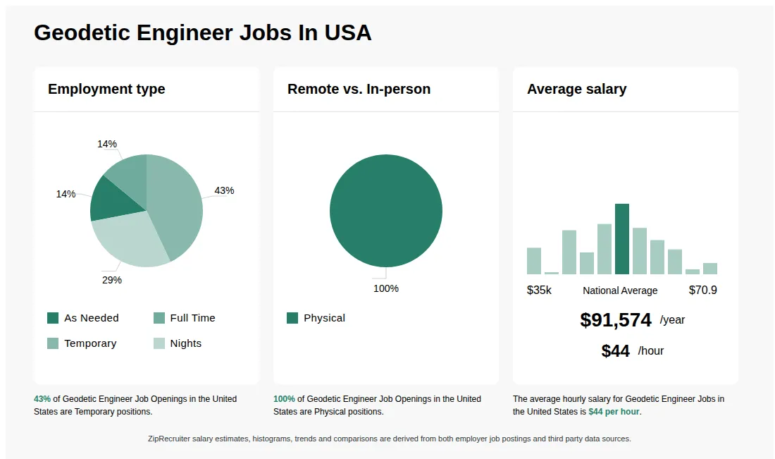
Infographic showing various Geodetic Engineer job openings in the United States as of September 2026, with employment types broken down into 87% Full Time, and 13% Part Time. Highlights an 100% In-person job distribution, with an average salary of $91,574 per year, or $44 per hour.

GIS Technician / Office Coordinator

Entarian

Virginia, MN • On-site

$60 - $80/hr

Other

Medical, Dental, Vision, Life, Retirement, PTO

Posted 7 days ago


Job description

Overview/ Job Responsibilities

The National Geodetic Survey’s (NGS) Spatial Reference Systems Division (SRSD) manages the geopotential reference system and operates NOAA's Continuously Operating Reference Station (CORS) network. To support its mission, SRSD runs two facilities focused on policy creation, training, field experiments, and instrument calibration, including the east coast Training and Testing Center in Corbin, VA. This site is equipped with geometric and geopotential calibration systems, as well as a suite of classic and cutting‑edge geodetic tools such as Global Navigation Satellite System (GNSS) receivers, differential and trigonometric levels, electronic distance measurement (EDM), absolute and relative gravimeter.

Position Description:

Entarian is seeking a candidate for our GIS Technician / Office Coordinator position to support operations at the facility in Corbin, VA. Job duties include:

  • Manage front‑desk operations, including greeting visitors, routing mail/emails, answering phones, and receiving packages.
  • Coordinate logistics for executive staff, including meeting scheduling, room preparation, presentation drafting, and minute‑taking.
  • Process staff Time & Attendance records and manage official government travel authorizations and vouchers.
  • Office inventory, supply procurement, property tracking (from acquisition to disposal), and government fleet maintenance logs.
  • Serve as a point of contact to assist field offices and staff with administrative procedures and organizational inquiries.
  • Perform spatial, graphical, and statistical data analysis, utilizing remote sensing and GIS techniques to support coastal and geospatial environment initiatives.
  • Develop new geodetic algorithms and tools to support the modernization of the National Spatial Reference System (NSRS).
  • Create, organize, and maintain digital and paper geodetic holdings, databases, and comprehensive metadata.
  • Collaborate with internal and external mapping professionals to ensure high‑level Quality Control (QC) on all products, and assist in publishing results online.
  • Conduct project analysis using PMBOK principles and collaborate with team members to propose innovative workflow and system improvements.
  • Author and prepare technical reports, memos, manuscripts, and project documentation.
  • Meet with leadership and stakeholders, design outreach materials, present at internal/external venues, and statistically analyze customer feedback.
  • Provide technical assistance and training to staff and end‑users.

The salary for this position is approximately $60,000 - $70,000/year.

This is an on‑site position supporting work in Corbin, VA.

Minimum Qualifications
  • Bachelors of Science degree in GIS, Geography, Math, or related STEM discipline
  • Ability to multitask, manage schedules, handle front‑desk/customer‑service tasks, maintain inventory, and keep meticulous logs or records.
  • Strong mathematical or statistical skills with the ability to learn and support GIS tool development.
  • Academic familiarity with geodetic concepts, datums, or the National Spatial Reference System (NSRS) is highly desirable.
  • Good understanding of the technology and a solid background in STEM.
  • Working knowledge of basic programming languages, e.g. Python, Matlabs, and managing metadata files, e.g. JSON, xxl, html, would be beneficial.
  • Interpersonal and organizational skills to act as a liaison between building occupants, technical staff, and management.
  • Attention to detail necessary for performing Quality Control on data and administrative workflows.
  • Ability to work effectively as a team and independently.
  • Must possess excellent oral and written communication skills and the ability to work with sensitive or classified data.
  • Ability to lift heavy boxes and equipment up to 50 lbs.
  • Must be a US Citizen or a Permanent Resident and be able to pass a Public Trust background investigation to obtain a security badge.
Benefits

All full‑time employees are eligible to participate in our flexible benefits package, which includes:

  • Medical, Rx, Dental, and Vision Insurance
  • 401(k) retirement plan with company‑matching
  • 11 Paid Federal Government Holidays
  • Paid Time Off (PTO)
  • Basic Life & Supplemental Life
  • Health Savings Account, Flexible Spending and Dependent Care Flexible Spending Accounts
  • Short‑Term & Long‑Term Disability
  • Employee assistance program (EAP)
  • Tuition Reimbursement, Personal Development & Learning Opportunities
  • Skills Development & Certifications
  • Professional Membership Reimbursement
  • Employee Referral Program
  • Competitive compensation plan
  • Discretionary variable incentive bonuses based on factors such as individual performance, business unit performance, and/or the company’s performance

Entarian is anEqual Opportunity and Affimative Action Employer. All qualified applicants will receive consideration for employment without regard to race, color, religion, sex, pregnancy, sexual orientation, gender identity, national origin, age, protected veteran status, or disability status.

#J-18808-Ljbffr