1

Geoinformatics Jobs (NOW HIRING)

$75 - $95/hr

A degree in Geography, Environmental Science, Remote Sensing, Geoinformatics, or a related field * Strong analytical and quantitative skills, with experience in geospatial data analysis * Hands-on ...

Utilizes knowledge of geoinformatics and experience to aid in departmental database management, map creation, special analysis, and automation. Ensure members of the Geology and Land Management ...

Applicants must have earned a Master's degree or higher (a PhD is strongly preferred) in Geography, Spatial Data Science, Geoinformatics, or a related discipline by July 1, 2027. This is a non-tenure ...

WI ยท On-site

$79.95 - $125.64/hr

A Master's degree or PhD in Remote Sensing, Geomatics, Geoinformatics, Computer Science, Physics, Engineering or a related field. * A solid understanding of optical/SAR Earth Observation, remote ...

next page

Showing results 1-20

geoinformatics information

See salary details

$43.5K

$78.9K

$112K

How much do geoinformatics jobs pay per year?

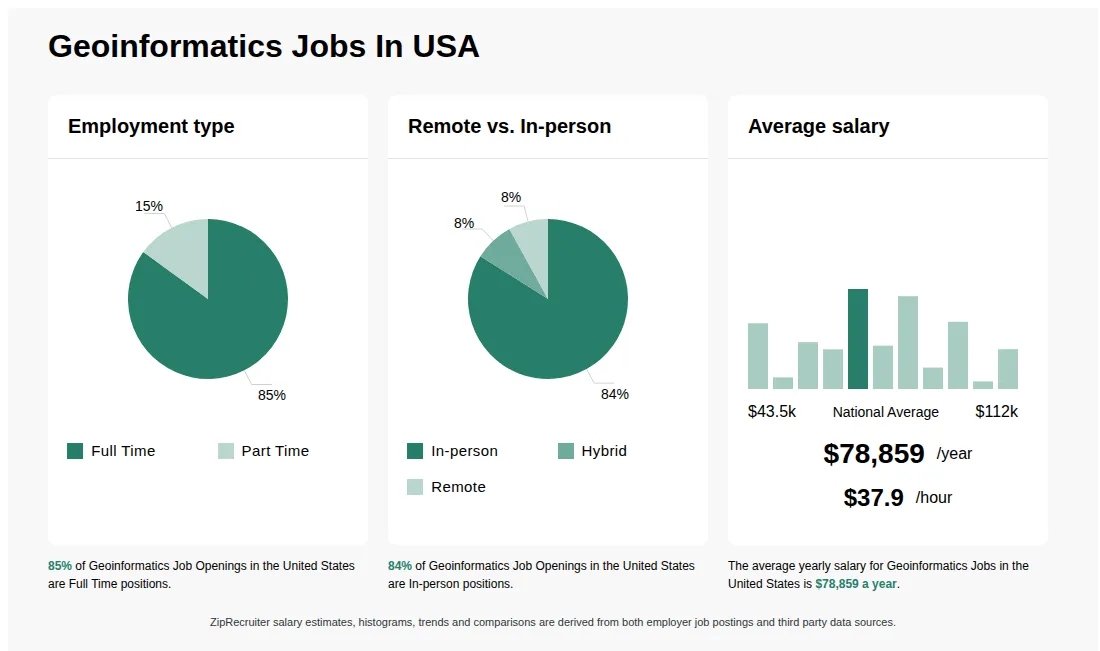
As of Sep 5, 2026, the average yearly pay for geoinformatics in the United States is $78,859.00, according to ZipRecruiter salary data. Most workers in this role earn between $66,000.00 and $94,000.00 per year, depending on experience, location, and employer.

What is a geoinformatics?

A Geoinformatics job involves the collection, analysis, and interpretation of geographic data using technologies like GIS (Geographic Information Systems), remote sensing, and GPS. Professionals in this field work in areas such as urban planning, environmental management, disaster response, and location-based services. They use spatial data to support decision-making, develop mapping solutions, and optimize geographic information systems for various industries.

What types of projects or tasks do geoinformatics professionals typically work on?

Geoinformatics professionals are often involved in projects such as spatial data collection and analysis, creating and maintaining digital maps, environmental impact assessments, and supporting urban planning or infrastructure development. Day-to-day responsibilities may include processing satellite imagery, developing geospatial databases, and collaborating with engineers, environmental scientists, or governmental agencies. Teamwork is common, especially when integrating geospatial data into larger projects or presenting findings to stakeholders. This role offers exposure to both fieldwork and office-based analysis, making it varied and dynamic for those passionate about technology and the environment.

What are the key skills and qualifications needed to thrive in geoinformatics, and why are they important?

To excel in Geoinformatics, you should have a solid background in geography, computer science, spatial analysis, and a relevant degree such as Geoinformatics, GIS, or Geospatial Science. Familiarity with GIS software (like ArcGIS or QGIS), remote sensing technologies, and coding languages such as Python or SQL is highly valued, along with certifications like GISP. Strong analytical thinking, problem-solving abilities, and effective communication skills are important for interpreting data and collaborating across disciplines. These competencies are crucial for delivering accurate spatial solutions that drive decision-making in urban planning, environmental monitoring, and other sectors.

Does geoinformatics have a future?

Geoinformatics is a growing field with increasing demand for professionals skilled in GIS, remote sensing, and spatial data analysis due to expanding applications in urban planning, environmental management, and disaster response. Advancements in technology and data availability suggest strong future job prospects for geoinformatics specialists.

Is GIS still in demand?

Geoinformatics professionals, including GIS specialists, are in strong demand due to the increasing reliance on spatial data analysis for urban planning, environmental management, and infrastructure development. Skills in GIS software like ArcGIS and QGIS, along with knowledge of remote sensing and data management, enhance employability in various industries.

What careers can you pursue with geoinformatics?

A degree or background in geoinformatics can lead to careers such as GIS analyst, remote sensing specialist, geospatial data scientist, cartographer, GIS technician, and environmental consultant. These roles often involve working with GIS software, spatial data analysis, and mapping technologies in various industries like urban planning, environmental management, and transportation. Certifications in GIS tools like ArcGIS or QGIS can enhance job prospects.

What cities are hiring for Geoinformatics jobs?

Cities with the most Geoinformatics job openings:

What are the most commonly searched types of Geoinformatics jobs?

The most popular types of Geoinformatics jobs are:

Infographic showing various Geoinformatics job openings in the United States as of August 2026, with employment types broken down into 100% Full Time. Highlights an 90% Physical, 5% Hybrid, and 5% Remote job distribution, with an average salary of $78,859 per year, or $37.9 per hour.

Firmware Developer / Image Analyst 80% (w/m/d) (Copy)

GMD

Indiana, PA โ€ข On-site

$80 - $110/hr

Other

Posted 18 days ago


Job description

GMD Careers | Embedded Firmware & Computer Vision Engineer โ€“ IoT Sensor Systems (m/f/d)

Firmware Developer / Image Analyst 80% (w/m/d) (Copy)

Hardware Engineering Landquart Switzerland Full time

Job description

Do you want to build intelligent systems that help protect people and the environment?

GMDยฎ GmbH develops AI-powered IoT sensor solutions for natural hazard prevention and climate resilience in alpine regions. Our autonomous systems combining embedded firmware, edge AI, and advanced sensing monitor rockfalls, landslides, floods, and critical infrastructure in real time. To strengthen our software and edge intelligence capabilities, we are looking for an Embedded & Computer Vision Engineer with a focus on efficient firmware development, on-device AI, and robust integration of sensor data into scalable platforms.

Your Responsibilities
  • Design and development of efficient firmware (C/C++) for our IoT sensor systems
  • Implementation of computer vision algorithms directly on edge devices
  • Integration of sensor data into the GeoSenseAIยฎ platform
  • Close collaboration with hardware development, data science, and geoinformatics
  • Occasional field deployments for installation, calibration, and maintenance of the systems
Qualifications & Experience
  • Completed degree in computer science or a comparable qualification
  • Solid knowledge of embedded programming
  • Practical experience with computer vision frameworks
  • Familiarity with IoT communication protocols (e.g., MQTT, LoRaWAN)
What to Expect
  • Contributing to exciting ClimateTech and AlpineTech projects
  • A young, motivated, and innovative team
  • Flexible working hours & remote work options
  • Working on real impact projects for climate resilience and natural hazard prevention
  • Growth opportunities in a rapidly expanding company
  • Modern technologies & plenty of creative freedom
Sounds exciting? Then apply now!

Please send your CV and a short cover letter.

#J-18808-Ljbffr