Position Overview Woolpert is hiring a Hydrographic Data Processing Specialist to join our Hydrographic Survey team in our Port Orchard, WA office or Wasilla, AK. Our team supports complex marine ...
Position Overview Woolpert is hiring a Hydrographic Data Processing Specialist to join our Hydrographic Survey team in our Port Orchard, WA office or Wasilla, AK. Our team supports complex marine ...
As an Offline Hydrographic Surveyor, you will be responsible for managing and processing large amounts of survey data collected from underwater environments. Your primary goal is to ensure the ...
New
As an Offline Hydrographic Surveyor, you will be responsible for managing and processing large amounts of survey data collected from underwater environments. Your primary goal is to ensure the ...
New

Specialized Data Processing (30%) * Support ongoing development and testing of the NOAA SatBathy software tool, cBLUE (comprehensive bathymetric lidar uncertainty estimator), and PSUE ...
New
Specialized Data Processing (30%) * Support ongoing development and testing of the NOAA SatBathy software tool, cBLUE (comprehensive bathymetric lidar uncertainty estimator), and PSUE ...
New

Hydrographic Survey Technician
Syracuse, NY · On-site
$21.65 - $28.85/hr
Be able to process Hydrographic data and create deliverables with little supervision * Be able to trailer a boat and launch/recover a boat. The minimum requirements we seek: * Degree strongly desired ...
Hydrographic Survey Technician
Syracuse, NY · On-site
$21.65 - $28.85/hr
Be able to process Hydrographic data and create deliverables with little supervision * Be able to trailer a boat and launch/recover a boat. The minimum requirements we seek: * Degree strongly desired ...
Hydrographic Survey Technician
Syracuse, NY · On-site
$21.65 - $28.85/hr
Be able to process Hydrographic data and create deliverables with little supervision * Be able to trailer a boat and launch/recover a boat. The minimum requirements we seek: * Degree strongly desired ...
Quick apply
Hydrographic Survey Technician
Syracuse, NY · On-site
$21.65 - $28.85/hr
Be able to process Hydrographic data and create deliverables with little supervision * Be able to trailer a boat and launch/recover a boat. The minimum requirements we seek: * Degree strongly desired ...

Hydrographic Surveyor
Fort Lauderdale, FL · On-site
Collect, process, and manage survey data for project deliverables. * Perform field calculations and ... Experience operating hydrographic survey equipment and small survey vessels. * Proficiency with ...
Quick apply
Hydrographic Surveyor
Fort Lauderdale, FL · On-site
Collect, process, and manage survey data for project deliverables. * Perform field calculations and ... Experience operating hydrographic survey equipment and small survey vessels. * Proficiency with ...
Hydrographic Party Chief
Syracuse, NY · On-site
$60K - $85K/yr
As a Hydrographer, your duties will include data QA/QC, equipment setup/calibration, trouble shooting, data acquisition, data processing, equipment maintenance, and production of final deliverables ...
Hydrographic Party Chief
Syracuse, NY · On-site
$60K - $85K/yr
As a Hydrographer, your duties will include data QA/QC, equipment setup/calibration, trouble shooting, data acquisition, data processing, equipment maintenance, and production of final deliverables ...
Software Developer, Emerging Hydrographic Data Systems
Durham, NH · On-site
$48 - $85/hr
Specialized Data Processing (30%) * Support ongoing development and testing of the NOAA SatBathy software tool, cBLUE (comprehensive bathymetric lidar uncertainty estimator), and PSUE ...
Posted today
Software Developer, Emerging Hydrographic Data Systems
Durham, NH · On-site
$48 - $85/hr
Specialized Data Processing (30%) * Support ongoing development and testing of the NOAA SatBathy software tool, cBLUE (comprehensive bathymetric lidar uncertainty estimator), and PSUE ...
Posted today
Hydrographic Survey Technician
Syracuse, NY · On-site
$21.65 - $28.85/hr
Be able to process Hydrographic data and create deliverables with little supervision * Be able to trailer a boat and launch/recover a boat. The minimum requirements we seek: * Degree strongly desired ...
Hydrographic Survey Technician
Syracuse, NY · On-site
$21.65 - $28.85/hr
Be able to process Hydrographic data and create deliverables with little supervision * Be able to trailer a boat and launch/recover a boat. The minimum requirements we seek: * Degree strongly desired ...
Collect, process, and manage survey data for project deliverables. * Perform field calculations and ... Experience operating hydrographic survey equipment and small survey vessels. * Proficiency with ...
Collect, process, and manage survey data for project deliverables. * Perform field calculations and ... Experience operating hydrographic survey equipment and small survey vessels. * Proficiency with ...
Hydrographic Party Chief
Syracuse, NY · On-site
$60K - $85K/yr
As a Hydrographer, your duties will include data QA/QC, equipment setup/calibration, trouble shooting, data acquisition, data processing, equipment maintenance, and production of final deliverables ...
Quick apply
Hydrographic Party Chief
Syracuse, NY · On-site
$60K - $85K/yr
As a Hydrographer, your duties will include data QA/QC, equipment setup/calibration, trouble shooting, data acquisition, data processing, equipment maintenance, and production of final deliverables ...
Hydrographic Party Chief
Syracuse, NY · On-site
$60K - $85K/yr
As a Hydrographer, your duties will include data QA/QC, equipment setup/calibration, trouble shooting, data acquisition, data processing, equipment maintenance, and production of final deliverables ...
Hydrographic Party Chief
Syracuse, NY · On-site
$60K - $85K/yr
As a Hydrographer, your duties will include data QA/QC, equipment setup/calibration, trouble shooting, data acquisition, data processing, equipment maintenance, and production of final deliverables ...
Hydrographic Surveyor
Fort Lauderdale, FL · On-site
Collect, process, and manage survey data for project deliverables. * Perform field calculations and ... Experience operating hydrographic survey equipment and small survey vessels. * Proficiency with ...
Hydrographic Surveyor
Fort Lauderdale, FL · On-site
Collect, process, and manage survey data for project deliverables. * Perform field calculations and ... Experience operating hydrographic survey equipment and small survey vessels. * Proficiency with ...
Hydrographic Surveyor
Fort Lauderdale, FL · On-site
$70 - $95/hr
Collect, process, and manage survey data for project deliverables. * Perform field calculations and ... Experience operating hydrographic survey equipment and small survey vessels. * Proficiency with ...
Hydrographic Surveyor
Fort Lauderdale, FL · On-site
$70 - $95/hr
Collect, process, and manage survey data for project deliverables. * Perform field calculations and ... Experience operating hydrographic survey equipment and small survey vessels. * Proficiency with ...
Hydrographic Office Technician / CAD Operator
Buffalo, NY · On-site
$52K - $65K/yr
Survey and hydrographic data processing experience * Familiarity with point clouds, terrain models, and surface generation * Basic understanding of survey coordinate systems and mapping standards
Quick apply
Hydrographic Office Technician / CAD Operator
Buffalo, NY · On-site
$52K - $65K/yr
Survey and hydrographic data processing experience * Familiarity with point clouds, terrain models, and surface generation * Basic understanding of survey coordinate systems and mapping standards
Hydrographic Office Technician / CAD Operator
Syracuse, NY · On-site
$52K - $65K/yr
Survey and hydrographic data processing experience * Familiarity with point clouds, terrain models, and surface generation * Basic understanding of survey coordinate systems and mapping standards
Hydrographic Office Technician / CAD Operator
Syracuse, NY · On-site
$52K - $65K/yr
Survey and hydrographic data processing experience * Familiarity with point clouds, terrain models, and surface generation * Basic understanding of survey coordinate systems and mapping standards
Hydrographic Office Technician / CAD Operator
Rochester, NY · On-site
$52K - $65K/yr
Survey and hydrographic data processing experience * Familiarity with point clouds, terrain models, and surface generation * Basic understanding of survey coordinate systems and mapping standards
Quick apply
Hydrographic Office Technician / CAD Operator
Rochester, NY · On-site
$52K - $65K/yr
Survey and hydrographic data processing experience * Familiarity with point clouds, terrain models, and surface generation * Basic understanding of survey coordinate systems and mapping standards

Senior Survey Manager
Baltimore, MD · On-site
$100 - $150/hr
Collect and process topographic data as referenced to hydrographic applications. * Support the maintenance, upkeep, and documentation of the survey vessel and company vehicles in concert with the ...
Senior Survey Manager
Baltimore, MD · On-site
$100 - $150/hr
Collect and process topographic data as referenced to hydrographic applications. * Support the maintenance, upkeep, and documentation of the survey vessel and company vehicles in concert with the ...
Hydrographic Office Technician / CAD Operator
Syracuse, NY · On-site
$52K - $65K/yr
Survey and hydrographic data processing experience * Familiarity with point clouds, terrain models, and surface generation * Basic understanding of survey coordinate systems and mapping standards
Quick apply
Hydrographic Office Technician / CAD Operator
Syracuse, NY · On-site
$52K - $65K/yr
Survey and hydrographic data processing experience * Familiarity with point clouds, terrain models, and surface generation * Basic understanding of survey coordinate systems and mapping standards
Hydrographic Office Technician / CAD Operator
Syracuse, NY · On-site
$52K - $65K/yr
Survey and hydrographic data processing experience * Familiarity with point clouds, terrain models, and surface generation * Basic understanding of survey coordinate systems and mapping standards
Hydrographic Office Technician / CAD Operator
Syracuse, NY · On-site
$52K - $65K/yr
Survey and hydrographic data processing experience * Familiarity with point clouds, terrain models, and surface generation * Basic understanding of survey coordinate systems and mapping standards
Hydrographic Data Processor information
See salary details
$12.26 - $14.31
8% of jobs
$16.17 is the 25th percentile. Wages below this are outliers.
$14.31 - $16.37
19% of jobs
$16.37 - $18.42
17% of jobs
The median wage is $19.05 / hr.
$18.42 - $20.48
19% of jobs
$21.95 is the 75th percentile. Wages above this are outliers.
$20.48 - $22.53
16% of jobs
$22.53 - $24.58
13% of jobs
$24.58 - $26.64
4% of jobs
$26.64 - $28.69
2% of jobs
$28.69 - $30.75
0% of jobs
$30.75 - $32.80
0% of jobs
$32.80 - $34.86
1% of jobs
$12
$20
$34
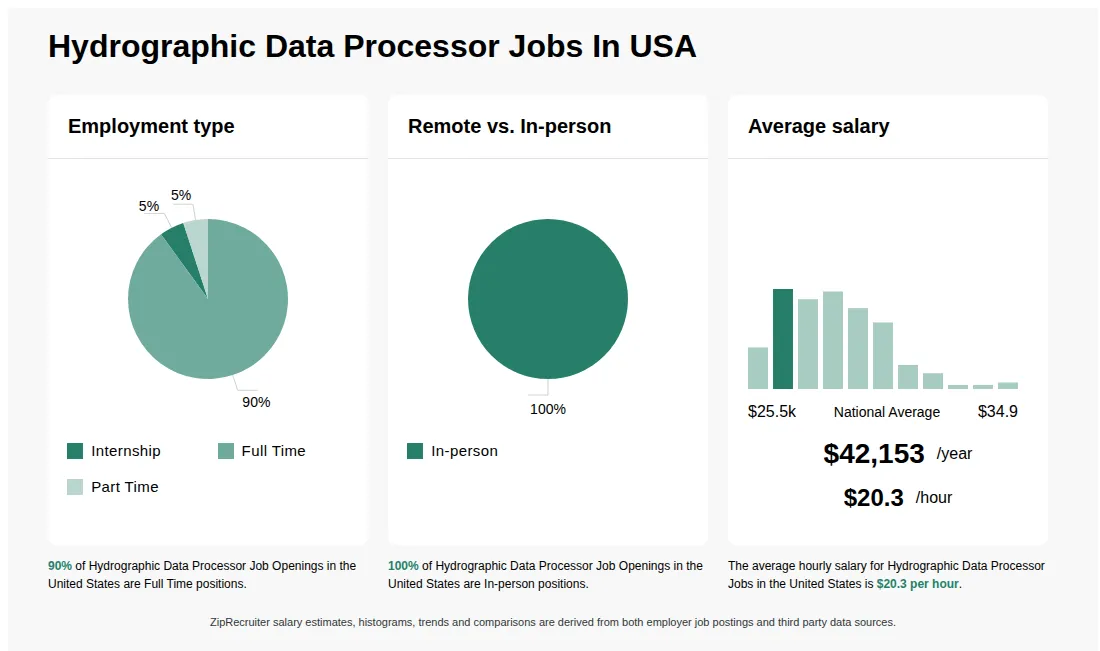
How much do hydrographic data processor jobs pay per hour?
As of Sep 4, 2026, the average hourly pay for hydrographic data processor in the United States is $20.27, according to ZipRecruiter salary data. Most workers in this role earn between $16.11 and $22.36 per hour, depending on experience, location, and employer.
What is a hydrographic data processor?
A Hydrographic Data Processor is responsible for processing, analyzing, and managing hydrographic survey data collected from sonar, LiDAR, and other geospatial technologies. They clean and format raw data, apply corrections, and generate maps, charts, and reports for marine navigation, construction, and research. This role requires proficiency in hydrographic software, GIS tools, and data quality control techniques. Hydrographic Data Processors work closely with surveyors, engineers, and GIS specialists to ensure accurate representation of underwater environments.
What does a hydrographic data processor do?
A typical day for a Hydrographic Data Processor involves reviewing, cleaning, and analyzing hydrographic survey data, validating its quality, and preparing detailed maps or reports for engineers, scientists, or maritime clients. You’ll often collaborate closely with field surveyors, vessel crews, and project managers to clarify data parameters and resolve anomalies, ensuring the output meets technical and regulatory standards. Regular communication is key as you may need to provide immediate feedback on survey data or work with multidisciplinary teams to integrate findings. This role generally involves both independent computer-based tasks and dynamic teamwork, making adaptability and clear communication essential for success.
What are the key skills and qualifications needed to thrive as a hydrographic data processor?
To thrive as a Hydrographic Data Processor, a strong background in geospatial sciences, data analysis, and hydrographic survey principles is essential—often supported by a relevant degree or diploma. Expertise in specialized software such as CARIS, QPS QINSy, or Hypack, as well as familiarity with GIS applications and quality control standards like IHO S-44, is typically required. Attention to detail, problem-solving abilities, and effective communication help professionals excel when collaborating with survey teams and interpreting complex data. These skills ensure accurate data processing and reporting, which are critical for navigation safety, marine construction, and environmental monitoring.
More about Hydrographic Data Processor jobs
What cities are hiring for Hydrographic Data Processor jobs?
Cities with the most Hydrographic Data Processor job openings:
What are the most commonly searched types of Hydrographic Data Processor jobs?
The most popular types of Hydrographic Data Processor jobs are:
What states have the most Hydrographic Data Processor jobs?
States with the most job openings for Hydrographic Data Processor jobs include:
What job categories do people searching Hydrographic Data Processor jobs look for?
The top searched job categories for Hydrographic Data Processor jobs are:

Full-time
Medical, Dental, Vision, Life, Retirement, PTO
Re-posted 12 days ago
Key responsibilities
Process multibeam and singlebeam hydrographic data using QPS Qimera, including data cleaning, refraction correction, sound velocity application, patch test validation, calibration review, surface generation, and uncertainty analysis.
Review and validate acquisition logs and metadata from QINSy to ensure proper integration into processing workflows, and perform side scan sonar processing and interpretation using SonarWiz, including mosaicking, gain normalization, target identification, and classification.
Export processed datasets for integration into AutoCAD Civil 3D, create bathymetric surfaces, generate contours and gridded soundings, perform volume calculations, prepare plan sheets and figures, and support the production of maps, mosaics, contact plots, cross sections, and GIS-compatible datasets.
Woolpert Inc. rating

7.8
Based on 10 frontline employees who took The Breakroom Quiz
242nd of 452 rated engineering
Job description
We seek to move the world forward through innovative thinking.
Woolpert is an award-winning, global leader in architecture, engineering, and geospatial services. We blend design excellence with cutting-edge technology to deliver exceptional client value. Our team is passionate about their work and committed to building the next generation of industry leaders, and as a certified Great Place to Work®, Woolpert embraces progress and innovation to create limitless opportunities for career growth.
Position Overview
Woolpert is hiring a Hydrographic Data Processing Specialist to join our Hydrographic Survey team in our Port Orchard, WA office or Wasilla, AK.
Our team supports complex marine survey projects across the U.S., including hydrographic surveys, geophysical investigations, and marine infrastructure assessments. This role is primarily office-based and focused on transforming raw field data into accurate, defensible deliverables that support engineering design, permitting, and construction.
This position is ideal for someone who enjoys working with large geospatial datasets, developing efficient processing workflows, and producing high-quality technical deliverables.
We are unable to provide visa sponsorship for this position. Applicants must already possess work authorization in the country where the job is located.
What You Will Do
Core Processing Workflow (Primary Role):
Geospatial & Deliverable Development:
Advanced Data Integration:
Quality Assurance & Workflow Development:
Collaboration & Project Support:
What You Will Bring:
Preferred Experience and Qualifications
What Success Looks Like in This Role
Benefits You Will Love
Certified as a Great Place to Work, Woolpert is one of the fastest-growing architecture, engineering, and geospatial companies in the world. With over 75 offices and countless projects around the globe, you'll work on meaningful assignments that improve quality of life around the world. In addition to offering competitive pay, we provide employees with a robust set of unique benefits, including:
Find out more about what Woolpert has to offer here: http://woolpert.com/about-us/
Woolpert is an equal-opportunity employer. Woolpert is committed to the full inclusion of all individuals. We recruit, train, compensate, and promote regardless of race, religion, color, national origin, sex, disability, age, veteran status, and other protected status as required by applicable law. You may view more about EEO on our website: Equal-Employment-Opportunity-The-Law.pdf and EEO is the Law Poster Supplement.
Applicants who require an accommodation throughout the application and interview process should request this in advance by contacting your Recruiter
To all agencies: Please, no phone calls or emails to any employee of Woolpert or any of our subsidiaries about this requisition. All resumes submitted by search firms/employment agencies to any employee at Woolpert via email, the internet, or in any form and/or method will be deemed the sole property of Woolpert, unless such search firms/employment agencies were engaged by Woolpert's Talent Acquisition Team for this requisition and a valid agreement is in place. In the event a candidate who was submitted outside of Woolpert's applicant process is hired, no fee or payment of any kind will be paid.
Woolpert is an award-winning, global leader in architecture, engineering, and geospatial services. We blend design excellence with cutting-edge technology to deliver exceptional client value. Our team is passionate about their work and committed to building the next generation of industry leaders, and as a certified Great Place to Work®, Woolpert embraces progress and innovation to create limitless opportunities for career growth.
Position Overview
Woolpert is hiring a Hydrographic Data Processing Specialist to join our Hydrographic Survey team in our Port Orchard, WA office or Wasilla, AK.
Our team supports complex marine survey projects across the U.S., including hydrographic surveys, geophysical investigations, and marine infrastructure assessments. This role is primarily office-based and focused on transforming raw field data into accurate, defensible deliverables that support engineering design, permitting, and construction.
This position is ideal for someone who enjoys working with large geospatial datasets, developing efficient processing workflows, and producing high-quality technical deliverables.
We are unable to provide visa sponsorship for this position. Applicants must already possess work authorization in the country where the job is located.
What You Will Do
Core Processing Workflow (Primary Role):
- Process multibeam and singlebeam hydrographic data using QPS Qimera, including:
- Data cleaning, refraction correction, and sound velocity application
- Patch test validation and calibration review
- Surface generation and uncertainty analysis
- Review and validate acquisition logs and metadata from QINSy to ensure proper integration into processing workflows
- Perform side scan sonar processing and interpretation using SonarWiz, including:
- Mosaicking and gain normalization
- Target identification and classification (e.g., debris, infrastructure, seabed features)
- Contact selection and reporting
Geospatial & Deliverable Development:
- Export processed datasets for integration into AutoCAD Civil 3D, including:
- Creation of bathymetric surfaces from high-density point clouds
- Generation of contours, breaklines, and gridded soundings (e.g., 25' x 25')
- Volume calculations and surface comparisons (existing vs. design or layered surfaces)
- Prepare plan sheets and figures consistent with project standards (e.g., ODMDS-style deliverables, channel surveys, dredge support)
- Support production of:
- Bathymetric maps and sounding sheets
- Side scan sonar mosaics and contact plots
- Cross sections and profile views
- GIS-compatible datasets and metadata
Advanced Data Integration:
- Integrate datasets across multiple sensors and platforms:
- Multibeam, singlebeam, side scan sonar, sub-bottom (as applicable)
- GNSS control and positioning data
- Terrestrial or mobile LiDAR for shoreline/structure tie-ins
- Assist with seabed characterization workflows, including combining backscatter and side scan interpretation where applicable
- Support SLAM-integrated datasets or GNSS-denied workflows (as applicable to project needs)
Quality Assurance & Workflow Development:
- Perform QA/QC checks to ensure data accuracy, consistency, and compliance with project specifications
- Document processing workflows and maintain reproducibility across projects
- Identify inefficiencies and contribute to improving internal processing standards
- Coordinate with field teams to resolve data gaps, anomalies, or acquisition issues
Collaboration & Project Support:
- Work closely with project managers and technical leads to meet project schedules and deliverable requirements
- Provide input to survey planning and acquisition strategies based on processing needs
- Support proposal efforts with technical approach language, example deliverables, and production estimates
What You Will Bring:
- Bachelor's degree in surveying, Geomatics, ocean engineering, geology, geography, spatial science, marine science, or related field
-
- 3 years + of Proficiency in AutoCAD Civil 3D for surface development and plan production
- Strong understanding of hydrographic survey principles and geospatial data workflows
- Detail-oriented mindset with a focus on producing accurate, defensible datasets
- Ability to manage multiple datasets and deadlines in a production environment
- Self-motivated, curious, and adaptable with strong problem-solving skills
Preferred Experience and Qualifications
- Experience with QINSy (acquisition awareness) and Qimera (processing)
- Experience with SonarWiz for side scan sonar processing and interpretation
- Experience with:
- Bathymetric surface generation and uncertainty evaluation
- Side scan mosaicking and contact reporting
- Volume calculations and layered surface analysis
- Familiarity with:
- Sub-bottom profiler data (CHIRP) and interpretation (a plus)
- GNSS processing (Trimble Business Center or similar)
- Global Mapper or GIS platforms
- Experience with LiDAR processing and integration workflows
- Strong data visualization and deliverable presentation skills
What Success Looks Like in This Role
- Produces clean, accurate bathymetric surfaces and deliverables with minimal rework
- Efficiently processes multibeam and side scan datasets across varying project types
- Understands how field decisions impact processing outcomes (and helps improve both)
- Contributes to consistent, repeatable workflows across the team
- Supports high-quality deliverables similar to those used in federal and coastal projects (e.g., channel surveys, ODMDS, infrastructure assessments)
Benefits You Will Love
Certified as a Great Place to Work, Woolpert is one of the fastest-growing architecture, engineering, and geospatial companies in the world. With over 75 offices and countless projects around the globe, you'll work on meaningful assignments that improve quality of life around the world. In addition to offering competitive pay, we provide employees with a robust set of unique benefits, including:
- Freedom to Work program: Set your own schedule and location (as appropriate).
- Principal program: Earn the opportunity to become an owner of the firm.
- Flexible paid time off/vacation: Take time off when it makes sense for you and your team.
- Career development: Explore a wide range of learning and growth opportunities within and across industries.
- Health, life, vision, and dental insurance: Cover all your medical bases.
- Paid sick time, retirement plan, fitness reimbursement, pet insurance, identity protection, technology stipend, employee assistance program, and more!
Find out more about what Woolpert has to offer here: http://woolpert.com/about-us/
Woolpert is an equal-opportunity employer. Woolpert is committed to the full inclusion of all individuals. We recruit, train, compensate, and promote regardless of race, religion, color, national origin, sex, disability, age, veteran status, and other protected status as required by applicable law. You may view more about EEO on our website: Equal-Employment-Opportunity-The-Law.pdf and EEO is the Law Poster Supplement.
Applicants who require an accommodation throughout the application and interview process should request this in advance by contacting your Recruiter
To all agencies: Please, no phone calls or emails to any employee of Woolpert or any of our subsidiaries about this requisition. All resumes submitted by search firms/employment agencies to any employee at Woolpert via email, the internet, or in any form and/or method will be deemed the sole property of Woolpert, unless such search firms/employment agencies were engaged by Woolpert's Talent Acquisition Team for this requisition and a valid agreement is in place. In the event a candidate who was submitted outside of Woolpert's applicant process is hired, no fee or payment of any kind will be paid.
What Woolpert Inc. employees say
Pay
Benefits
Hours and flexibility
Workplace
Get the full story on Breakroom

About Woolpert
Sourced by ZipRecruiter
Industry
Civil engineering construction
Company size
501 - 1,000 Employees
Headquarters location
Dayton, OH, US
Year founded
1911