The GIS Specialist is the primary point of contact for the enterprise GIS platform, fostering ... Publish and manage map, feature, image, geoprocessing, and real-time (GeoEvent) services.
The GIS Specialist is the primary point of contact for the enterprise GIS platform, fostering ... Publish and manage map, feature, image, geoprocessing, and real-time (GeoEvent) services.

GIS System Administrator
Memphis, TN · On-site
It is the responsibility of the GIS System Administrator to aid both GIS users and non-users in the ... Experience with geospatial data, geodatabases, analysis, maps, services, and applications. MS Azure ...
GIS System Administrator
Memphis, TN · On-site
It is the responsibility of the GIS System Administrator to aid both GIS users and non-users in the ... Experience with geospatial data, geodatabases, analysis, maps, services, and applications. MS Azure ...
GIS System Administrator
Memphis, TN · On-site
It is the responsibility of the GIS System Administrator to aid both GIS users and non-users in the ... Experience with geospatial data, geodatabases, analysis, maps, services, and applications. MS Azure ...
GIS System Administrator
Memphis, TN · On-site
It is the responsibility of the GIS System Administrator to aid both GIS users and non-users in the ... Experience with geospatial data, geodatabases, analysis, maps, services, and applications. MS Azure ...

GIS Analyst II
Nashville, TN · On-site
This intermediate level opportunity provides and prepares GIS data support, including analysis support, data conversion/migration and map productions, with minimal supervision on projects. What You ...
GIS Analyst II
Nashville, TN · On-site
This intermediate level opportunity provides and prepares GIS data support, including analysis support, data conversion/migration and map productions, with minimal supervision on projects. What You ...

Familiarity with web-based GIS applications, dashboards, and interactive mapping tools used for public engagement and decision support. * Basic knowledge of database management systems (e.g., SQL ...
Familiarity with web-based GIS applications, dashboards, and interactive mapping tools used for public engagement and decision support. * Basic knowledge of database management systems (e.g., SQL ...
GIS Analyst II
Nashville, TN · On-site
This intermediate level opportunity provides and prepares GIS data support, including analysis support, data conversion/migration and map productions, with minimal supervision on projects. What You ...
GIS Analyst II
Nashville, TN · On-site
This intermediate level opportunity provides and prepares GIS data support, including analysis support, data conversion/migration and map productions, with minimal supervision on projects. What You ...
GIS Team Lead
Nashville, TN · On-site
$81K - $109K/yr
Creates final media projects including CD-ROMs, hardcopy maps, and documentation. * Develops key ... Investigates and learns new technologies, especially in the GIS industry. * Recruits, hires ...
GIS Team Lead
Nashville, TN · On-site
$81K - $109K/yr
Creates final media projects including CD-ROMs, hardcopy maps, and documentation. * Develops key ... Investigates and learns new technologies, especially in the GIS industry. * Recruits, hires ...
GIS Team Lead
Nashville, TN · On-site
$81K - $109K/yr
Creates final media projects including CD-ROMs, hardcopy maps, and documentation. * Develops key ... Investigates and learns new technologies, especially in the GIS industry. * Recruits, hires ...
GIS Team Lead
Nashville, TN · On-site
$81K - $109K/yr
Creates final media projects including CD-ROMs, hardcopy maps, and documentation. * Develops key ... Investigates and learns new technologies, especially in the GIS industry. * Recruits, hires ...

GIS Web AI Developer, Senior Associate
Nashville, TN · On-site
$77K - $202K/yr
Responsibilities - Utilizing Esri Mapping Software and Geographic Information System (GIS) Applications to analyze and visualize geographic data - Implementing GIS Architecture and Conversion ...
GIS Web AI Developer, Senior Associate
Nashville, TN · On-site
$77K - $202K/yr
Responsibilities - Utilizing Esri Mapping Software and Geographic Information System (GIS) Applications to analyze and visualize geographic data - Implementing GIS Architecture and Conversion ...

Stormwater GIS Intern
Germantown, TN · On-site
$25/hr
Generates maps, figures, and supporting documentation (e.g., tables, summaries) from the collected GIS data. Analyzes the collected data to highlight and map areas with high-severity issues, helping ...
Stormwater GIS Intern
Germantown, TN · On-site
$25/hr
Generates maps, figures, and supporting documentation (e.g., tables, summaries) from the collected GIS data. Analyzes the collected data to highlight and map areas with high-severity issues, helping ...
Generates maps, figures, and supporting documentation (e.g., tables, summaries) from the collected GIS data Analyzes the collected data to highlight and map areas with high-severity issues, helping ...
Generates maps, figures, and supporting documentation (e.g., tables, summaries) from the collected GIS data Analyzes the collected data to highlight and map areas with high-severity issues, helping ...

Construction Coordinator (GIS)
Nashville, TN · On-site
$32 - $38/hr
We are seeking a highly skilled GIS Construction Coordinator to lead the engineering coordination ... Intermediate working knowledge of Google Earth/Maps. * Exemplary communication skills with ...
Construction Coordinator (GIS)
Nashville, TN · On-site
$32 - $38/hr
We are seeking a highly skilled GIS Construction Coordinator to lead the engineering coordination ... Intermediate working knowledge of Google Earth/Maps. * Exemplary communication skills with ...

Real Estate GIS Analyst
Memphis, TN · On-site
Minimum of 2 - 3 years of experience in GIS, Market Research, Business Analytics or similar field ... We travel the country to tie together what we see on a map and what is taking place on the ground ...
Real Estate GIS Analyst
Memphis, TN · On-site
Minimum of 2 - 3 years of experience in GIS, Market Research, Business Analytics or similar field ... We travel the country to tie together what we see on a map and what is taking place on the ground ...
Real Estate GIS Analyst
Memphis, TN · On-site
We travel the country to tie together what we see on a map and what is taking place on the ground ... Minimum of 2 - 3 years of experience in GIS, Market Research, Business Analytics or similar field ...
Real Estate GIS Analyst
Memphis, TN · On-site
We travel the country to tie together what we see on a map and what is taking place on the ground ... Minimum of 2 - 3 years of experience in GIS, Market Research, Business Analytics or similar field ...

Field Data Specialist - Travel position
Nashville, TN · On-site
$22 - $25/hr
Candidates with experience in mapping, property appraisal, inspections, GIS, data collection, data entry, land surveying, or any outdoor, detail-oriented fieldwork tend to excel here. If you're ...
Field Data Specialist - Travel position
Nashville, TN · On-site
$22 - $25/hr
Candidates with experience in mapping, property appraisal, inspections, GIS, data collection, data entry, land surveying, or any outdoor, detail-oriented fieldwork tend to excel here. If you're ...
Field Data Specialist - Travel position
Nashville, TN · Remote
$22 - $25/hr
Candidates with experience in mapping, property appraisal, inspections, GIS, data collection, data entry, land surveying, or any outdoor, detail-oriented fieldwork tend to excel here. If you're ...
Field Data Specialist - Travel position
Nashville, TN · Remote
$22 - $25/hr
Candidates with experience in mapping, property appraisal, inspections, GIS, data collection, data entry, land surveying, or any outdoor, detail-oriented fieldwork tend to excel here. If you're ...

Utilize the ESRI GIS mapping system and work management system in preparing documents and/or electronic files needed for ALDP surveys and periodic data reports. * Support training of Field Operations ...
Utilize the ESRI GIS mapping system and work management system in preparing documents and/or electronic files needed for ALDP surveys and periodic data reports. * Support training of Field Operations ...

Marine Reserves Ecologist (Natural Resource Specialist 1)
Newport, TN · On-site
$50 - $70/hr
GIS mapping * presenting information in public forums * report writing This position is a member of ODFW's Nearshore Ecology Program, which houses the marine habitat and marine reserves teams. The ...
Marine Reserves Ecologist (Natural Resource Specialist 1)
Newport, TN · On-site
$50 - $70/hr
GIS mapping * presenting information in public forums * report writing This position is a member of ODFW's Nearshore Ecology Program, which houses the marine habitat and marine reserves teams. The ...
Ability to use GIS, mapping, and data visualization tools to support decision making. * Knowledge of personal computer applications and digital literacy * Ability to meet deadlines and keep ...
Ability to use GIS, mapping, and data visualization tools to support decision making. * Knowledge of personal computer applications and digital literacy * Ability to meet deadlines and keep ...
Ability to use GIS, mapping, and data visualization tools to support decision making. * Knowledge of personal computer applications and digital literacy * Ability to meet deadlines and keep ...
Ability to use GIS, mapping, and data visualization tools to support decision making. * Knowledge of personal computer applications and digital literacy * Ability to meet deadlines and keep ...
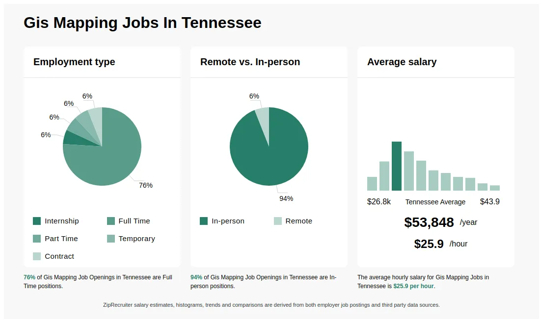
Gis Mapping information
See Tennessee salary details
$12.87 - $15.69
5% of jobs
$15.69 - $18.51
13% of jobs
$19.46 is the 25th percentile. Wages below this are outliers.
$18.51 - $21.32
21% of jobs
The median wage is $23.17 / hr.
$21.32 - $24.14
17% of jobs
$24.14 - $26.95
13% of jobs
$29.16 is the 75th percentile. Wages above this are outliers.
$26.95 - $29.77
8% of jobs
$29.77 - $32.59
7% of jobs
$32.59 - $35.40
5% of jobs
$35.40 - $38.22
5% of jobs
$38.22 - $41.04
3% of jobs
$41.04 - $43.85
2% of jobs
$12
$25
$43
How much do gis mapping jobs pay per hour?
As of Sep 7, 2026, the average hourly pay for gis mapping in Tennessee is $25.89, according to ZipRecruiter salary data. Most workers in this role earn between $19.62 and $30.53 per hour, depending on experience, location, and employer.
What is a GIS mapping job?
GIS mapping jobs focus on the support and use of the geographic information system, which uses multiple layers of data to create maps for many different purposes. In this field, you may help gather and verify information for the system, use software to track your routes, and prepare customized maps and reports as needed. You may be asked to prioritize tasks, network with others to minimize duplication of effort, resolve customer or client inquiries, and interpret construction documents. Many GIS mapping jobs involve a significant amount of fieldwork, but analysis professionals usually work from a home or company office.
What is a GIS mapping professional?
GIS Mapping professionals are specialists who use Geographic Information Systems (GIS) to collect, analyze, and visualize spatial data. They create maps and spatial datasets that help organizations make informed decisions about geography-related issues, such as urban planning, environmental management, and transportation. Their work involves using specialized software to manipulate data, produce maps, and interpret patterns and trends. GIS Mapping professionals often collaborate with engineers, surveyors, and planners to provide insights that guide projects and policy decisions.
What are the key skills and qualifications needed to thrive as a GIS mapping specialist, and why are they important?
To thrive as a GIS Mapping Specialist, you need a solid background in geography, cartography, or a related field, along with experience in spatial data analysis. Proficiency with GIS software such as ArcGIS or QGIS, and familiarity with spatial databases and data collection tools, is essential. Strong attention to detail, analytical thinking, and effective communication skills help in interpreting data and collaborating with stakeholders. These skills are crucial for producing accurate maps and spatial data analyses that inform decision-making across various industries.
What are some common challenges faced by GIS mapping professionals when working with large datasets, and how are they typically addressed?
GIS Mapping professionals often encounter challenges when handling large or complex spatial datasets, such as slow software performance, data integration issues, and ensuring data accuracy. To address these, teams typically utilize high-performance GIS software, optimize data storage formats, and establish clear data management protocols. Collaboration with IT specialists and regular data validation checks are also important to maintain project efficiency and data reliability.
What is the difference between Gis Mapping vs GIS Technician?
| Aspect | Gis Mapping | GIS Technician |
|---|---|---|
| Required Credentials | GIS certifications, relevant degrees | GIS certifications, relevant degrees |
| Work Environment | Fieldwork, data collection, mapping projects | Office-based, data analysis, map creation |
| Employer & Industry Usage | Government agencies, environmental firms, urban planning | Government agencies, utilities, engineering firms |
| Common Search & Comparison | Yes | Yes |
Gis Mapping involves creating and updating geographic maps, often including field data collection and spatial analysis. GIS Technicians support GIS projects through data management, analysis, and map production. While both roles require similar credentials and work in related environments, Gis Mapping emphasizes fieldwork and map creation, whereas GIS Technicians focus on data processing and technical support within GIS systems.
Is GIS mapping a good career?
GIS mapping is a viable career that involves using geographic information systems to analyze and visualize spatial data. It requires skills in GIS software, data analysis, and sometimes programming, with job opportunities in government, environmental, urban planning, and private sectors. The field offers steady demand and opportunities for specialization and advancement.
Is GIS mapping still in demand?
GIS mapping professionals are in ongoing demand across industries such as urban planning, environmental management, and transportation, as geographic data analysis remains essential for decision-making. Skills in GIS software like ArcGIS or QGIS, along with spatial data analysis, are highly valued, and employment opportunities are expected to grow with increased reliance on geospatial technology.
More about Gis Mapping jobs
What are the most commonly searched types of Gis Mapping jobs in Tennessee?
The most popular types of Gis Mapping jobs in Tennessee are:
What are popular job titles related to Gis Mapping jobs in Tennessee?
For Gis Mapping jobs in Tennessee, the most frequently searched job titles are:
What job categories do people searching Gis Mapping jobs in Tennessee look for?
The top searched job categories for Gis Mapping jobs in Tennessee are:
What cities in Tennessee are hiring for Gis Mapping jobs?
Cities in Tennessee with the most Gis Mapping job openings:

Full-time
Medical, Dental, Vision, Life, Retirement, PTO
Posted 4 days ago
Oak Ridge National Laboratory rating

8.8
Based on 16 frontline employees who took The Breakroom Quiz
14th of 121 rated laboratories
Job description
Requisition Id 17035
Overview:
The Integrated Operations Support Division (IOSD) at Oak Ridge National Laboratory (ORNL) seeks a Geographic Information Systems (GIS) Specialist to serve as the functional system administrator for ArcGIS Enterprise, and partners with IT staff and data owners across ORNL. The GIS Specialist is the primary point of contact for the enterprise GIS platform, fostering customer relationships by proactively identifying, implementing, and communicating continuous improvement efforts.
The GIS Specialist will build awareness of existing GIS capabilities, develop, and implement new tools and workflows, and support the vision, roadmap, standards, and governance for GIS across the Directorate. Supported functional areas include site, facility, and asset management, utilities distribution, logistics, environmental safety & health, strategic planning, construction, engineering, emergency management, and security.
Major Duties/Responsibilities:
- Serve as the functional system administrator for ArcGIS Enterprise (Portal, Server, Data Store) and associated applications and datasets.
- Design, develop, and maintain web maps, web applications, web scenes, dashboards, and mobile apps using ArcGIS Experience Builder, Dashboards, Survey123, and related tools.
- Administer and optimize enterprise geodatabases, including SQL views, schema design, privileges, versioning, and replica management.
- Support data interoperability efforts to integrate CAD, BIM, tabular, and other datasets into enterprise GIS; ensure correct coordinate systems and projections (including ORNL custom coordinates).
- Develop and maintain Python scripts, Arcade expressions, attribute rules, and automated processes (including batch scripts and Windows Task Scheduler jobs).
- Publish and manage map, feature, image, geoprocessing, and real-time (GeoEvent) services.
- Implement and support offline GIS workflows, mobile field work, GPS-based data collection, and road network analysis (Network Analyst).
- Maintain data governance, metadata standards, and documentation for Enterprise GIS assets.
- Develop and maintain GIS platform documentation including Software Quality Assurance, Business Impact Analysis, Contingency Planning, System Security Plans, etc.
- Work closely with managers, process owners, IT staff, and end users to understand requirements, prioritize enhancements, and implement system/process improvements.
- Provide general troubleshooting and user support to both GIS technical staff and non-technical map users
- Administer licensing and user accounts for desktop and server applications.
- Coordinate software procurement, planning, installation and vendor relations and support including training, coordinating software demonstrations, benchmarking, etc.
- Deliver ORNL’s mission by aligning behaviors, priorities, and interactions with our core values of Impact, Integrity, Teamwork, Safety, and Service. Promote equal opportunity by fostering a respectful workplace – in how we treat one another, work together, and measure success.
Basic Qualifications:
- A BS/BA degree in GIS, geography, environmental science, environmental informatics, computer science, engineering, natural sciences, or a related field.
- Minimum 5 years of relevant GIS experience.
- Proficient with ArcGIS Pro and ArcGIS Enterprise; capable of architecting, developing, and maintaining web maps and web applications from enterprise data.
- Experience with GIS data analysis, data cleaning/curation, and integration of multiple data formats (including CAD).
- Working knowledge of SQL and relational databases for GIS workflows.
Preferred Qualifications:
- MS/MA degree in geography, GIS, environmental science, environmental informatics, computer science, engineering, natural sciences, or a related field.
- Experience as a technical lead, system administrator, or architect for an enterprise GIS environment.
- Experience working with facilities and operations organizations, city/county governments, or utilities.
- Advanced experience with:
- ArcGIS Experience Builder and Dashboards
- Enterprise geodatabases (e.g., SQL Server) including versioning and replicas
- ArcGIS Server and Portal administration
- Network Analyst and road network management
- GeoEvent Manager and real-time GIS
- Experience integrating GIS with asset management systems (e.g., Octave EAM) or other enterprise business systems.
- Experience with Python and/or Arcade for GIS automation, analysis, or business logic.
- Background in software support or customer-facing technical roles, including training and documentation.
- Ability to work collaboratively with a diverse group of stakeholders and contribute to team goals.
- Strong prioritization, communication, problem-solving skills, and attention to detail.
Special Requirements:
- Visa sponsorship is not available for this position.
- This position requires the ability to obtain and maintain an HSPD-12 PIV badge.
For employment at Oak Ridge National Laboratory (ORNL), a Real ID compliant form of identification will be required. Additionally, ORNL is subject to Department of Energy (DOE) access restrictions. All employees must also be able to obtain and maintain a federal Personal Identity Verification (PIV) card as mandated by Homeland Security Presidential Directive 12 (HSPD-12) and Department of Energy (DOE) Order 473.1A, which requires a favorable post-employment background investigation.
To obtain this credential, new employees must successfully complete and pass a Federal Tier 1 background check investigation. This investigation includes a declaration of illegal drug activities, including use, supply, possession, or manufacture within the last year. This includes marijuana and cannabis derivatives, which are still considered illegal under federal law, regardless of state laws.
For Hybrid eligible positions:
This position is located in Oak Ridge, Tennessee and requires onsite presence. We offer a flexible work environment that supports both the organization and the employee. A hybrid/onsite working arrangement may be available with this position, which provides flexibility to work periodically from your home, while reporting onsite to the Oak Ridge, Tennessee location on a weekly and regular basis.
About ORNL:
As a U.S. Department of Energy (DOE) Office of Science national laboratory, ORNL has an impressive 80-year legacy of addressing the nation’s most pressing challenges. Our team is made up of over 7,000 dedicated and innovative individuals! Our goal is to create an environment where a variety of perspectives and backgrounds are valued, ensuring ORNL is known as a top choice for employment. These principles are essential for supporting our broader mission to drive scientific breakthroughs and translate them into solutions for energy, environmental, and security challenges facing the nation.
ORNL offers competitive pay and benefits programs to attract and retain individuals who demonstrate exceptional work behaviors. The laboratory provides a range of employee benefits, including medical and retirement plans and flexible work hours, to support the well-being of you and your family. Employee amenities such as on-site fitness, banking, and cafeteria facilities are also available for added convenience.
Other benefits include the following: Prescription Drug Plan, Dental Plan, Vision Plan, 401(k) Retirement Plan, Contributory Pension Plan, Life Insurance, Disability Benefits, Generous Vacation and Holidays, Parental Leave, Legal Insurance with Identity Theft Protection, Employee Assistance Plan, Flexible Spending Accounts, Health Savings Accounts, Wellness Programs, Educational Assistance, Relocation Assistance, and Employee Discounts.
If you have difficulty using the online application system or need an accommodation to apply due to a disability, please email: ORNLRecruiting@ornl.gov.
This position will remain open for a minimum of 5 days after which it will close when a qualified candidate is identified and/or hired.
We accept Word (.doc, .docx), Adobe (unsecured .pdf), Rich Text Format (.rtf), and HTML (.htm, .html) up to 5MB in size. Resumes from third party vendors will not be accepted; these resumes will be deleted and the candidates submitted will not be considered for employment.
ORNL is an equal opportunity employer. All qualified applicants, including individuals with disabilities and protected veterans, are encouraged to apply. UT-Battelle is an E-Verify employer.
What Oak Ridge National Laboratory employees say
Pay
Benefits
Hours and flexibility
Workplace
Get the full story on Breakroom

About Oak Ridge National Laboratory
Sourced by ZipRecruiter
Industry
Scientific research and development services
Company size
5,001 - 10,000 Employees
Headquarters location
Oak Ridge, TN, US
Year founded
1943