... aerial imagery, LiDAR, and other geospatial data products. Responsibilities * Conduct workflow ... photogrammetry, Remote sensing, or surveying is preferred. * Experience with ESRI is required.
... aerial imagery, LiDAR, and other geospatial data products. Responsibilities * Conduct workflow ... photogrammetry, Remote sensing, or surveying is preferred. * Experience with ESRI is required.
... aerial imagery, LiDAR, and other geospatial data products. Responsibilities * Conduct workflow ... photogrammetry, Remote sensing, or surveying is preferred. * Experience with ESRI is required.
... aerial imagery, LiDAR, and other geospatial data products. Responsibilities * Conduct workflow ... photogrammetry, Remote sensing, or surveying is preferred. * Experience with ESRI is required.
... aerial imagery, LiDAR, and other geospatial data products. * Conduct workflow processes with a ... photogrammetry, Remote sensing, or surveying is preferred. * Experience with ESRI is required.
... aerial imagery, LiDAR, and other geospatial data products. * Conduct workflow processes with a ... photogrammetry, Remote sensing, or surveying is preferred. * Experience with ESRI is required.
... aerial imagery, LiDAR, and other geospatial data products. Responsibilities * Conduct workflow ... photogrammetry, Remote sensing, or surveying is preferred. * Experience with ESRI is required.
... aerial imagery, LiDAR, and other geospatial data products. Responsibilities * Conduct workflow ... photogrammetry, Remote sensing, or surveying is preferred. * Experience with ESRI is required.
Aerial Photogrammetry information
See Florida salary details
$11.32 - $12.59
3% of jobs
$12.59 - $13.86
9% of jobs
$13.86 - $15.14
11% of jobs
$15.28 is the 25th percentile. Wages below this are outliers.
$15.14 - $16.41
9% of jobs
$16.41 - $17.69
14% of jobs
The median wage is $17.90 / hr.
$17.69 - $18.96
19% of jobs
$20.23 is the 75th percentile. Wages above this are outliers.
$18.96 - $20.23
9% of jobs
$20.23 - $21.51
16% of jobs
$21.51 - $22.78
7% of jobs
$22.78 - $24.06
1% of jobs
$24.06 - $25.33
1% of jobs
$11
$20
$25
How much do aerial photogrammetry jobs pay per hour?
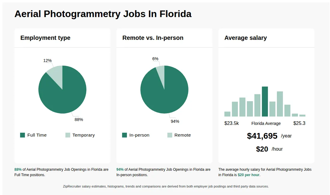
As of Sep 5, 2026, the average hourly pay for aerial photogrammetry in Florida is $20.05, according to ZipRecruiter salary data. Most workers in this role earn between $15.29 and $20.67 per hour, depending on experience, location, and employer.
What is aerial photogrammetry?
An Aerial Photogrammetry job involves capturing and analyzing aerial images to create maps, 3D models, and measurements of terrain, structures, or landscapes. Professionals in this field use drones, aircraft, or satellites equipped with cameras and sensors to gather geospatial data. They process and interpret the imagery using specialized software to support industries like surveying, construction, agriculture, and urban planning. The role requires expertise in remote sensing, GIS applications, and data analysis to ensure accurate and useful results.
What are the key skills and qualifications needed for aerial photogrammetry?
To thrive in Aerial Photogrammetry, you need strong skills in geospatial analysis, image interpretation, and a solid background in geography, surveying, or a related field. Familiarity with specialized software such as GIS (Geographic Information Systems), photogrammetric processing tools (e.g., Pix4D, Agisoft Metashape), and drone operation certifications are typically required. Excellent attention to detail, problem-solving abilities, and strong teamwork and communication skills help professionals excel in collaborative project environments. These competencies are crucial to ensure the accurate collection, processing, and interpretation of aerial data for mapping, surveying, and analysis projects.
What are some common challenges faced in aerial photogrammetry?
In aerial photogrammetry roles, professionals often encounter challenges related to variable weather conditions, site accessibility, and ensuring high data accuracy during image capture and processing. Handling and calibrating drones or other aerial equipment safely and efficiently is also a key concern, as is managing large datasets and troubleshooting software issues. Collaboration with surveyors, GIS specialists, and project managers is essential for integrating aerial data into broader mapping or engineering projects. Overcoming these challenges requires a combination of technical expertise, attention to detail, and effective communication with the team.
What are the most commonly searched types of Aerial Photogrammetry jobs in Florida?
The most popular types of Aerial Photogrammetry jobs in Florida are:
What are popular job titles related to Aerial Photogrammetry jobs in Florida?
For Aerial Photogrammetry jobs in Florida, the most frequently searched job titles are:
What job categories do people searching Aerial Photogrammetry jobs in Florida look for?
The top searched job categories for Aerial Photogrammetry jobs in Florida are:

Temporary
Medical, Dental, Vision, Life, Retirement
Re-posted 10 days ago
Job description
Overview
WGI is currently seeking a Geospatial Analyst I, for DOD SkillBridge Transitioning Service Members, to be part of our Geospatial Divisionin our Huntsville, AL and West Palm Beach, FL, offices.
At WGI, you will find talented, passionate associates providing exceptional service in collaborative, team-driven environments, all while having fun and enjoying the work they do. We work to stay ahead of the curve by investing in the latest tools and technology. As one of the nation's top consulting firms, we consistently strive to promote efficiency, cultivate a culture our associates can proudly embrace, and empower our associates to advance their career growth at WGI, and beyond.
WGI is always looking for remarkable individuals to join our team and help us grow in our vision. If you think you are an innovative, self-motivated team player, and want to shape your community, join our WGI team today!
WGI offers a complete Benefits package including Medical, Dental, Vision, LTD & STD, Life Insurance, 401k with match, PLA, Holidays, HSA with company contribution, Pet insurance, and an Employee assistance program.
The Geospatial Analyst I works in a team environment executing necessary geospatial tasks required to build data products that are both high accuracy and high quality. Successful analysts contribute to the implementation and maintenance of data, services and applications mainly focusing on the development and distribution of vector datasets, aerial imagery, LiDAR, and other geospatial data products.
Responsibilities- Conduct workflow processes with a methodological approach based on Geographic Information System (GIS), CAD, and remote sensing technology. This may include the pre-processing of imagery, digitizing vector features, performing LiDAR classification, extraction of features from LiDAR, and assisting with metadata and project reporting.
- Serve as a technical specialist, providing advice on geospatial standards, product generation, and geodatabase management.
- DOD SkillBridge Transitioning Service Members Only
- BA/BS in Geography or related earth sciences field (additional experience may be substituted for education) is preferred.
- 0-2 years (3-5 if not degreed) of increasing technical knowledge in GIS, LiDAR, photogrammetry, Remote sensing, or surveying is preferred.
- Experience with ESRI is required.
- Candidates with experience in GeoCue, TerraScan, LP360, or TopoDOT will be given higher consideration.
- Strong written and oral communication skills are required.
- Candidates should have a demonstrated ability to work both independently and in a team environment to execute geospatial workflows.
- Strong analytical skills and experience solving geospatial problems is highly desired.
Applicants must be currently authorized to work in the U.S. on a full-time basis. We are unable to sponsor or take over the sponsorship of employment visas.
Physical Demands
The physical demands are representative of those that must be met by an employee to successfully perform the essential functions of this job. Reasonable accommodations may be made to enable individuals with disabilities to perform essential functions. Work is performed in an office setting. Hand-eye coordination is necessary to operate a computer, keyboard, and mouse. The use of a telephone headset will allow for virtual communication with team members through Zoom and/or Microsoft Teams. While performing the duties of this job, the employee is often required to sit for prolonged periods, use hands/fingers to handle, feel, or operate objects, tools, or controls reach with hands and arms, speak, and hear. Specific vision abilities required by this job include close vision, distance vision, color vision, peripheral vision, depth perception, and the ability to adjust focus.
If you have what it takes to join our growing organization and want to be part of a dedicated team, please apply today. In return, WGI provides a competitive salary and an outstanding work environment. WGI is anEqual Opportunity Employer/Veterans/Disabled.
WGI does not accept any unsolicited resumes. Should any 3rd party agency or recruiter forward or submit any resume(s) to a WGI associate without a pre-existing contractual agreement, the submitted resume(s) will be deemed the property of WGI, and no placement fee will be provided.
All agencies and vendors are required to have a signed WGI vendor agreement from the WGI Chief HR Officer permitting them to work directly through our Talent Acquisition team. Obtaining this signed vendor agreement is the only way you will receive payment. Verbal or written commitments from any other member of our staff will not be binding.
All third-party recruiting/supplemental staffing agencies are expected to familiarize themselves and abide by this policy.
Employment Type: TEMPORARY